Drought and suffering in Garissa

Drought and suffering in Garissa

I last visited Garissa more than 30 years ago. It was a fairly wild journey to get there; three days waiting in Isiolo for an armed convoy to pass through, clambering on top of a load of grain sacks in the pitch dark early hours to join twenty-odd displaced Ethiopians, Kenyans and Somalis crouching precariously on an overloaded and ancient truck; hours spent standing alone in searing heat before being picked up by a passing Norwegian family working for VSO, then 90 long minutes hanging on the the cab rail on the back of a pickup driven by two crazy young Indian traders driving as if Somali shifta were on there tail (who knows maybe they were, few risked driving in this region without military escort at that time). I arrived in Garissa late afternoon, with still a couple of hours daylight remaining. I was young and brash then, I knew little of the politics of the region or the hardships of the local people; I was pissed because there was no beer in the town to be bought. I was coated in a layer of red desert dust and, after 10 hours on the back of open vehicles felt as dessicated as if I’d been in a drying oven. As far as I was concerned Garissa was just a transit point for me, one I hoped I wouldn’t be spending too much time in. I wandered past the truck stop, chatted to a few drivers and quickly ascertained that no-one was going anywhere soon, so I wandered to the end of town to pitch my tent. I was quickly disabused of this idea when a military truck pulled up and several soldiers informed me that it was too dangerous to camp out here. A little over an hour later I was sipping coffee sitting in my tent inside the military compound, surrounded by ten foot barb wire fences, surveying my supplies: coffee, margarine and some rather old bread. Jeez, this is going to be along night, I can’t even wander in to the local chai shops and chat to the truck drivers. As it happened I was quite wrong. I had barely finished my coffee when a young soldier walked up and announced that the camp commander wished to see me. This are going from bad to worse I thought; now I was about the get a dressing down for my stupidity and probably have my papers scrutinised in minute detail for errors. Not so! The commander was a young guy, no more than ten years older than me, from Nairobi; he appeared to feel as out of place here as I did and had seized upon the opportunity to discuss things other than the price of cattle or the latest incursions of shifta with someone from outside this dry and dusty world. I had a most entertaining evening learning about George Adamson’s encampment nearby (Kora, where George released lions was just a few miles away); Joy Adamson’s temper and temperatment and the problems cre3ated by lack of security in the region. A quite surreal touch was added when I first arrived at the commander’s lodge by a young Somali prisoner who was also in the building being questioned. He immediately began protesting that his handcuffs should be removed, as it was embarressing to be so shackled when a foreigner (especially a white person) was present.

I have always retained fond memories of Garissa, despite seeing little of the town. Garissa appears to have expanded enormously in that time; tarmac road have appeared and multi-storey buildings. But life is now probably harder than ever. Security is still a problem, twin grenade attacks on a local restuarant and the local prison occured in the town just four days ago, but that is not the main problem. Northern Kenya is in the grip of the worst drought in half a century. Displaced pastoralist tribespeople live in makeshift huts around the periphery of the town. Cattle, the sole income for many, are dying in their hundreds, thousands of families are now dependant on food aid, children no longer go to school as families move in search of water. In the attention-deficit disorded media world, such slow grinding misery rarely makes the news, yet the drought goes on. There are however, projects working to change this situation. One of the best seems to be the Tana River Drought Recovery Project, managed by Kenya’s Red Cross (Facebook album)

More information at dowser.org

Colin
Stripey Howling Hancock, Exeter busker

Stripey Howling Hancock, Exeter busker
Stripey Howling Handcock busking, Exeter city centre, Devon, England.

Stripey Howling Handcock busking, Exeter city centre.


Nigel ‘Stripey howling’ Hancock is almost a landmark in Exeter.  His distinctive guitar style, a blend of ragtime, blues and celtic, can be heard somewhere in the city centre on most days.  Stripey doesn’t just play in Exeter though; at different times of the year he can be heard in Poland, Switerland and other European countriesw, taking part on busking and street art festivals, most notably the buskerbus tours.  Stripey has his own page, while his music can be bought here or simply ask him for a CD if you’re in Exeter.

For those interested in the technical aspects, this is an HDR image, created from a single RAW image, then converted to monochrome and slightly tweaked in Photoshop.  If you are interested in Photoshop training please contact me ,

Diving the trawl 2: filming the trawl

Diving the trawl 2: filming the trawl

A couple of years ago I wrote a piece called lessons is stupidity: diving the trawl , describing the first time I dived on a trawler’s net.  I’ve done this a few times over the years, most recently a couple of days ago.  We re-did this because cameras improve and the quality of images improves, so we need to re-shoot.  We also wanted to get some slightly different images this time; in particular we wanted to get images as the trawl net was being hauled, when it was just below the surface.

As events transpired the weather conditions were against us. Strong winds prevailed through most of August and much of September.  It was not until the last week of September, with equinoxal gales just around the corner, that we finally found a brief window of opportunity.  Due to vessel availability and other logistical constraints we had only one day available that week in which everything came together.  The weather was marginal but we were now well into autumn with precious few opportunities remaining this year, so we decided to take a chance and go for it.

Trawl net close up as it is hauled to the surface, Lyme Bay, Southwest England, Colin Munro Photography

Trawl net close up as it is hauled to the surface, Lyme Bay, Southwest England,

We began to load the trawl net on to our vessel on a bright but chilly morning.  A stiff breeze was whipping whitecaps on the sea beyond the shelter of the harbour, but the latest forecast indicated this should die away during the morning.  By the time the net had been hauled aboard and rigged and all our gear on deck it was midday; Lynsey, John and I were hot, dirty and sweaty but pretty satisfied everything was as ready as it could be.  The wind had not abated.  But we were now committed, so warps were unhitched and we nosed out into the bay.  A 60 square mile exclusion area for bottom towed fishing gear (trawls and scallop dredges) has been established within the centre of Lyme Bay to protect the fragile reefs found there (this came about in part due to our earlier work looking at the impacts of bottom-fishing gear).  We therefore had a two hour steam to get to a suitable location beyond this closed area in which to set the trawl.  That gave us two hours for the wind to die down and the sea state to drop away.   If we were lucky the wind would not yet have stirred up the seabed enough to destroy the visibility.  The longer the wind continued the more our chances of success diminished.

Filming the trawl net being deployed

John does all the hard work while I film the trawl net being deployed

We reach a shallow bay outside the closed area, about 20 metres depth, shortly after 2.30p.m.  The wind was still fresh and we knew it was not looking good for getting workable conditions on the seabed.  We decided to have a test dip to check out visibility before deploying the trawl.

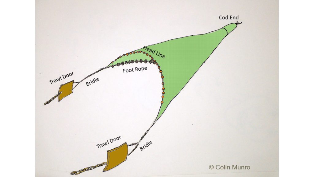
A bottom trawl, otter trawl. © Colin Munro

Diagram of the bottm trawl used (not to scale)

I wanted to stay dry in order to do some surface filming of the trawl being deployed, so this task fell to my dive buddy Lynsey.  A quick dip was enough to convince her it was no-go.  Seabed visibility was no more than one metre.  Quite apart from it being impossible to film the trawl operating in such conditions it would also have been too dangerous to be around heavy moving fishing gear.  Reluctantly I called the dive off and we reverted to plan B.

Setting up the Gates camera housing in the trawler’s tiny wheelhouse is always a bit of a challenge.

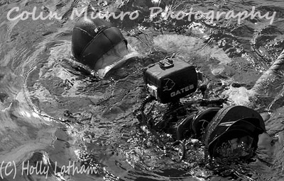
I also wanted to get footage of the trawl as it was being hauled, a little below the surface.  This we could do as the near-surface visibility, although far from perfect, was much better than that close to the seabed.  However, there were the added logistical problems that the trawl net had to be hauled with the boat steaming forward at a speed of several knots, way too fast to swim or hang on holding a large camera.  We had worked a method where I would be dropped off close to the net as it reached the surface, and drift back alongside it, filming as I went.  It sounded plausible – I mean what could possibly go wrong?  Before this we set up some surface and just below shots at speed, working from a small inflatable.

John and Lynsey in deep discussion as we trawl for a couple of hours.

John and Lynsey in deep discussion as we trawl for a couple of hours.

Poor Lyndsey had the unenviable task of heaving cameras across the tubes to me and hanging on to my legs as I dangled head-down in the water trying desperately to: a) get the vaguest impression of what I was filming through the spray and turbulence, and b) stop my camera from being ripped from my fingers.  From the surface I must have presented a highly comical sight, legs waving and coughing and spluttering to the surface every few seconds.  From a personal perspective it felt rather like what I imagine being waterboarded by a firehose while suspended upsidedown might feel like.   Having had my sinuses thoroughly irrigated at high pressure, it was now time to get into the water, before I had time to ponder the stupidity of my actions and change my mind.  At any rate, the sun was racing toward the horizon and light was fading rapidly, so it was either now or  call it off and wait ’til next year.    In the event the plan worked almost like clockwork; we were even able to repeat the operation so that I could run one haul taking stills and a second taking video footage.  Given the relatively poor visibility (~ 4 metres near the surface) I was quite pleased with the results.

The stupid grin you wear when it all works out.

Nothing got broken (apart from a torn shoulder muscle – my stupidity when the trying to work parallel to the waterflow) and everything worked pretty much as it should.  October gales have now set in so there will be no more dives on fishing gear this year.

Note:  As with my previous blog on this topic, this is NOT in any way designed to be a ‘how to’ guide to diving on trawl nets.  I have deliberately ommitted key elements to try to avoid giving this impression.  Diving around nets and heavy moving fishing gear obviously involves a significant element of risk if not approached with great care and planning.  I have presented this in a fairly light-hearted manner and should be taken as such rather than a technical guide.

Sex and death in the seagrass

A common or European cuttlefish, Sepia officinalis, trapped in monofilament bottom set nets, Brixham Harbour. Each year nets are set around seagrass beds (Zostera marina) where cuttlefish come in to breed. Colin Munro Photography
A common or European cuttlefish, Sepia officinalis, trapped in monofilament bottom set nets, Brixham Harbour.  Each year nets are set around seagrass beds (Zostera marina) where cuttlefish come in to breed. Colin Munro Photography

A common or European cuttlefish, Sepia officinalis, trapped in monofilament bottom set nets, Brixham Harbour. Each year nets are set around seagrass beds (Zostera marina) where cuttlefish come in to breed. Image No. MBI000305.

Intelligent life. Few divers who have ever encountered an octopus or cuttlefish underwater cannot have been struck by a sense of an alien intelligence staring hard at them, assessing whether you are friend or foe and what you are likely to do next. That cephalopods (octopi, cuttlefish, squid and their kin) are bright has now become common knowledge; yet this is still something that sits uneasily with their molluscan nature. Great apes, whales and dolphins are easier to accept; they are mammals and so not that distantly related to us. But cephalopods? They are not even vertebrates; first cousins to slugs, snails and slipper limpets. Their blood is greeny-blue not red as the oxygen carrying molecule is copper-based rather than the iron-based haemoglobin in all mammals. They really are shape-shifting aliens from inner space. And yet, when a cuttlefish rises out of the sand or seagrass to hover in front of you, you get a real sense of cogs turning and a logical decision-making process taking place. That may, of course simply be down their binocular vision; we tend to almost intuitively associate this with intelligence (it is designed, after all, to assess distance, form mental 3D images of the World and judge when and how to strike at prey). That there is real intelligence behind those eyes is most elegantly demonstrated by the octopus, which has joined the elite group of animals that have demonstrated the use of tools to manipulate their environment in the wild. The veined octopus has recently been filmed collecting and stacking discarded coconut shells halves to use as a shelter. So far it is the only invertebrate to do so.

Cuttlefish breeding. The seagrass beds of South Devon have long been a favourite dive habitat of mine. They provide gentle, sunlit dives where one can float along in the hope of encountering a pipefish, mating sea hares and, at the right time of year, cuttlefish arriving to lay eggs. Watching a female cuttlefish lay eggs is a fascinating experience. Each pointed black egg is attached to a tuft of seagrass or weed one at a time. The female will hover before it, then after a few minutes contemplation will move forward to firmly grasp the stem with her tentacles and pull it towards her. After a minute she draws back again, to reveal a new shiny, pointed black eggs bound to the stem by a band extending out of the egg case. This process with continue for over an hour, until the stem is wrapped in what resembles a bunch of black, pointed grapes.

A common or European cuttlefish, Sepia officinalis, trapped in monofilament bottom set nets, Brixham Harbour.  Each year nets are set around seagrass beds (Zostera marina) where cuttlefish come in to breed. Colin Munro Photography.

A female common or European cuttlefish, Sepia officinalis, trapped in monofilament bottom set nets, Brixham Harbour. A male hovers nearby and will eventually also be entangled. Other males hover in the background. Image No. MBI000270.

While the eggs are laid a gang of males hover in attendance. When cuttlefish mate the male transfers the spermatophores (sperm packages) to within the females buccal cavity, using his modified fourth arm (the hectcotylus). The hectocotylus is then used to break open the spermatophores, releasing the sperm which is then temporarily stored within the female’s buccal cavity. If she subsequently mates with another male it will direct jets of water into her buccal cavity to attempt to flush out earlier sperm deposits. Consequently the most recent mate will hover above her, warding off other males that will hang around, to ensure that it is his genetic material that is passed on rather than that of his upstart rivals.

Cuttlefish in nets. Cuttlefish are, of course, a valuable catch for fishermen. They are caught in trawls out at sea and also in set nets deployed around their inshore breeding grounds. Cuttlefish grow quickly and most die shortly after breeding, so those caught after they have laid their eggs will not have any real effect on future populations. Unfortunately however, nets are often laid around the edges of breeding grounds such as seagrass nets, thus cuttlefish are caught not only when leaving the breeding ground but also when arriving, before they breed. The nets do not kill them, but they are often quite badly damaged as they twist and the fine line cuts into their flesh. Indeed I often wonder how they can be sold after their flesh is so ripped up. If a female is caught then inevitably a number of males arriving will hang around her until they too are caught. A trapped female may remain their for up to twelve hours before the nets are hauled, so the potential for catching large numbers of breeding cuttlefish is quite high. So far, this practice does not seem to have noticeably affected local cuttlefish populations. It is nonetheless rather disconcerting to watch such lovely animals twisting and turning for hours on end.

Update. In the past couple of years I, and other local divers, have seen notably fewer cuttefish hanging around in the shallow bays of South Devon during the breeding season.  This may simply be due to factors like the lousy weather we’ve had during the past couple of summers; it may also be due to the almost impenetrable ring of nets set on the edge of these bays.

Images. All the images in this blog are available to license.  You can search all my online stock images at my www.colinmunroimages.com  Cuttlefish images, Sepia officinalis images, fishing images, stock images.

Fishing canoe (pirouge) being landed at sunset, Senegal

Fishing canoe (pirouge) being landed at sunset, Senegal
Pirogue fishermen at sunset, Senegal, West Africa Image. MBI000914

Pirogue fishermen at sunset, Senegal, West Africa Image. MBI000914


Fishing canoe (pirouge) being landed at sunset, Senegal. Image MBI000914. Please email me, quoting this number if you’d like to license use of this image or purchase a fine art print.

A wooden fishing canoe returns from a day at sea, and men haul the boat and engine up the sandy beach as the sun sets.  M’bour, Senegal.

Fishing boat at sunset, Eastern Mediterranean, off Egypt

Fishing boat at sunset, Eastern Mediterranean, off Egypt
Egyptian fishing boat at sunset, Eastern Mediterranean Sea. Image MBI000912. Colin Munro Photography

Egyptian fishing boat at sunset, Eastern Mediterranean Sea. Image MBI000912.

Fishing boat at sunset, Eastern Mediterranean, off Egypt. Please email me, quoting this number if you’d like to license use of this image or purchase a fine art print.
I spend a couple of weeks working off in the eastern Mediterranean Sea, a few miles off the Nile delta, a while back.  It was mid-winter, and we spent much of the time dodging gales.  Although we were in a fairly substantial boat, waves piled up high in the shallow waters off the delta, so work was completed in brief sorties, then running back to port with four or five metres waves chasing us.  When the sea was calm however, it was absolutely beautiful, with the most stunning sunsets.  Calm weather also brought out large numbers of fishing trawlers.  At one time I counted twelve trawlers all within sight of us; it seems highly unlikely that such fishing is sustainable and indeed I saw precious little catch when nets were hauled.  As the sun set all nest were hauled and the boats headed back to port leaving us with the sea to ourselves until the sun rose again.  I watched this boat inch past the dipping sun, with an almost blood red sky as a backdrop.  There has been vistually no editing to this image – the sky really did look like that.  Sometimes you have to really work to get great pics, and sometime you just need to be there.

The fishermen of M’bour

M'bour, Senegal. Fishermen haul a small fishing pirogue (wooden canoe) up on to the beach at sunset.  Image MBI000739

M’bour, Senegal. Fishermen haul a small fishing pirogue (wooden canoe) up on to the beach at sunset.

In November 2008 I spent two weeks living in M’bour, a dusty transit stop and fishing port halfway between Dakar and the Gambia. I spent this time getting to know the fishermen, going to sea with them, learning how they worked, the risks they took travelling up to 20 miles offshore in leaky open canoes without so much as a compass to guide them. I learned how they spent days at sea in tiny canoes, sleeping in the bottom of them, risking storms or being swept out to sea. As there canoes have no lights they also run the risk of being mown down by trawlers at night. Many do lose their lives each year, but economic pressures are causing a growing number of young men to turn to fishing. This brings its own problems; the fishery is almost completely unregulated but anecdotal reports suggest this is having a significant impact on stocks of some species.  Robust data is hard to come by, given the unregulated nature of this fishery, but the Senegalese Directorate of Marine Fisheries estimated that in 2004 a little over 6000 such canoes were operating along the coast of Senegal.  The main species caught are small sardinella (Sardinella aurita and S. maderenis) and horse mackerel (Trachurus trachurus). In 2008 the fishery off M’bour and nearby Joal Fadiouth was considered over-exploited (source FAO,Fisheries Circular No. 1033, 2008).

Fishing canoe,  or pirogue, being lanched off beach on wooden rollers, M'bour,  Senegal.  Image MBI000628

Our fishing canoe, or pirogue, being lanched off beach on wooden rollers, M’bour, Senegal.

 Now fully laden, our ancient outboard is securely fastened with bailing twine. Note the well balanced ice box perched toward the stern of the canoe.

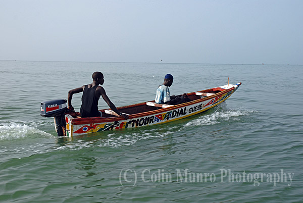
M'bour, Senegal. Two Senegalese fishermen head out to sea in a small pirogue (traditional wooden canoe).  Image MBI000909.

M’bour, Senegal. Two Senegalese fishermen head out to sea in a small pirogue (traditional wooden canoe).

I spent a day at sea on one of these tiny boats. Simply making it through the surf was quite an acheivement; the boat had no ballast and was so top heavy, due to ourselves and the large box of ice we were carrying, that we appeared in imminet danger of capsizing. Fortunately we shipped quite a lot of water quite quickly during a rather shaky lauching. This few inches of seawater inside our boat at least gave us some stability by providing some ballast, albeit not a recommended way of doing so. Powered by an ancient 15hp outboard engine attached by bailing twine and duck tape, we headed out to sea for about three hours, by which time I estimated we were about fifteen miles offshore. For the first 30 minutes or so we saw a few other boats, but they quickly dispensed in differing directions and we were along. We had set off in a grey haze that quickly enveloped the land and turned the sun in to a nothing more than a lighter glow in the haze. Both sea and sky were otherwise quite featureless.  I watched with growing alarm as the sky changed; growing dark and heavy, and a stiffening breeze spring up.  Maybe two hours out we came upon a similar canoe, drifting aimlessly as their similarly ancient outboard engine had died.  To its crew’s consternation our boat skipper offered not to towed them to back to port but to a point where they ‘had a better chance of being spotted’ by a home-bound canoe.  So for half and hour or so we towed them further out to sea (or at least it seemed that direction to me) before leaving them to anchor on what appeared an equally featureless spot of grey sea as the one where we picked them up.  We never saw them again; I rather hope this indicated that they had indeed been towed ashore.

Our unhappy fishermen drop anchor and start their wait for a passing vessel after we tow them to a ‘better’ location.

At one point Pape, the boat’s owner, asked me which direction I thought M’bour lay.  With no visual clues to guide me I based my guess on the heading I thought we had set off on.  Apparently I was almost 180 degrees out.  I asked Pape how he could tell, with no compass or electronic aids; the wind direction he informed me.  So, I enquired cautiously, does it always blow from the same direction this time of year?  No, he cheerfully informed me, sometimes we get lost.  I rather wished I hadn’t asked.

Eventually we arrived at the fishing grounds.  What exactly identified them as ‘the fishing grounds’ I have no idea.  Hooks were baited with little, frozen prawns from our icebox and handlines set.  A small stove was fired up in the middle of the canoe and sugary tea the colour and consistency of stockholm tar brewed.  A cup was passed around from which we all took small sips; more than would most likely have resulted in irreversible damage to my intestines.  This was supplemented by joints also passed around.  Tea, reefers and small amounts of rice and peanut porridge (gosi) were pretty much all the crew had to survive on apart from whatever they caught.   Around two hours passed, in which time we had caught maybe a dozen fish, mostly sardinella, horse mackerel and a few bigeye grunt (Brachydeuterus auritus).  Barely enough to feed us at sea, let alone provide a wage for all three fishermen.  Around four in the afternoon, by which time the chop on the sea had risen significantly and little whitecaps had started to appear, we finally decided to head back inshore.  Much to my relief, Pape’s sense of direction proved accurate.

The sun was setting when we finally reached M’bour, and there have been few occasions when I’ve been quite so pleased to step on to dry land.  Pape and his crew would probably go to sea again tomorrow, maybe staying out for one or two nights this time.  I thought that night of the meagre catch we returned with after a day at sea, of the broken down canoe we had come across and of the stories Pape had told me of getting caught in a storm and drifting helplessly for three days before sighting land.  Overfishing is a massive problem on the West coast of Africa.  Much of this problem is actually due to poorly regulated fishing by large trawlers from outside Senegal: Russian, Korean, Japanese, Chinese and European boats.  It has been estimated that a large trawler will, on one good day, catch as much as fifty pirogues will in a year.  Vessels are licensed by the Senegalese Government who argue that if they don’t sell licenses then neighbouring countries will; stocks may still suffer and Senegal will lose vauable revenue (Grégoire Allix, le Monde/Worldcrunch, 2011). What is a matter of concern about the long term effects of overfishing for us in the West can be a question of survival for some on the coast of Senegal.

M'bour, Senegal. Fifteen miles offshore a Senegalese fishermen hand lines for fish over a sand bank. Image MBI000908.

One of our crew handlines, delicately holding the line waiting patiently for a bite.

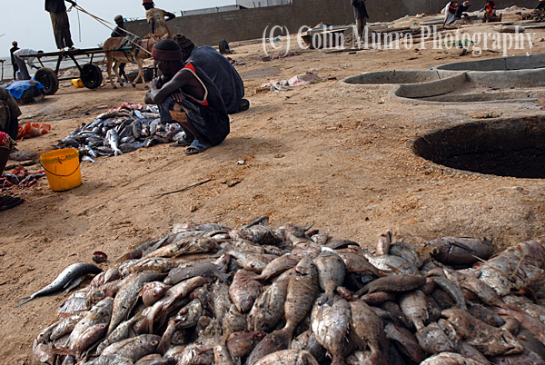
Fish salting pans, M'bour, Senegal. Image MBI000609.

Fish salting pans, M’bour, Senegal.

View more of my images of  Senegal and from other regions of the  World here at my Colin Munro Images website.

Aitutaki atoll, Cook Islands, South Pacific

Aitutaki atoll, Cook Islands, South Pacific

Coconut palms trees and white sand beach and blue sky, Tapuaetai island (one foot island), Aitutaki atoll, Cook Islands. Image MBI000566.

Coconut palms trees and white sand beach and blue sky, Tapuaetai island (one foot island), Aitutaki atoll, Cook Islands. Image MBI000566.

.Coconut palms trees and white sand beach and blue sky, Tapuaetai island (one foot island), Aitutaki atoll, Cook Islands. Image MBI000566. Please email me, quoting this number if you’d like to license use of this image or purchase a fine art print.
Aitutaki, Cook Islands, South Pacific.
Position 18° 51? 0? S, 159° 47? 24? W (WGS84).
I wrote recently that bright sunshine and blue skies did not feature in my photography. Okay, i lied! I doesn’t feature that often, but when it comes to South Pacific islands what else can one do? Aitutaki, Cook Islands, must be one of the most idyllic places on earth; sunshine, pristine white beaches, warm clear waters teeming with life, coconut palms and wonderful friendly people. I, like most people who visit I suspect, felt my time there was all too short. I’ve limited this post to a a couple of beach views and pictures of coconut palms (there wil be more). Aitutaki is a coral atoll, the second largest of the Cook Islands (after Roratonga) and also the second most visited. The atoll comprises 22 islands in total; the largest, central island is Arutanga. The remaining islands lie on top of the traingular fringing coral reef that encloses the lagoon. Tapuaetai island (one foot island,) where these images were taken, is located near the southern tip of the fringing reef. it is a small island of sand and coconut palms, less than a kilometre across.
Recently germinated coconut palms trees ( Cocos nucifera) on a white sand beach, Tapuaetai island (one foot island), Aitutaki atoll, Cook Islands, South Pacific. Image MBI000904.

Recently germinated coconut palms trees ( Cocos nucifera) on a white sand beach, Tapuaetai island (one foot island), Aitutaki atoll, Cook Islands, South Pacific. Image MBI000904.

.Recently germinated coconut palms trees ( Cocos nucifera) on a white sand beach, Tapuaetai island (one foot island), Aitutaki atoll, Cook Islands, South Pacific. Image MBI000904. Please email me, quoting this number if you’d like to license use of this image or purchase a fine art print.
The coconut palm, Cocos nucifera, is a member of the family Arecaceae (palm family). It is found around the tropics. The cocnut seed is buoyant and may be distributed widely by ocean currents. Coconut palms flourish in sandy soils and are tolerant of high salt levels. They grow fastes where mean annual temperates are around 80 degree F (27 degrees C).
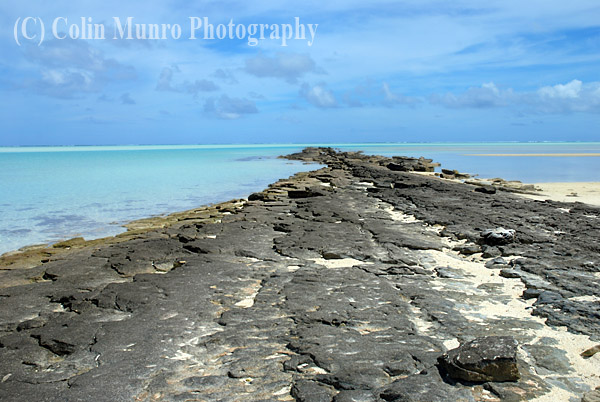
Coral platform, Tapuaetai island (one foot island), Aitutaki atoll, Cook Islands, South Pacific. Image MBI000905.

Coral platform, Tapuaetai island (one foot island), Aitutaki atoll, Cook Islands, South Pacific. Image MBI000905.

. Coral platform, Tapuaetai island (one foot island), Aitutaki atoll, Cook Islands, South Pacific. Image MBI000905. Please email me, quoting this number if you’d like to license use of this image or purchase a fine art print.
Coconut palms trees and white sand beach and blue sky, Tapuaetai island (one foot island), Aitutaki atoll, Cook Islands. Image MBI000906.

Coconut palms trees and white sand beach and blue sky, Tapuaetai island (one foot island), Aitutaki atoll, Cook Islands. Image MBI000906.

Coconut palms trees and white sand beach and blue sky, Tapuaetai island (one foot island), Aitutaki atoll, Cook Islands. Image MBI000906. Please email me, quoting this number if you’d like to license use of this image or purchase a fine art print.

Recently germinated coconut ( Cocos nucifera) on a white sand beach. Image MBI000907.

Recently germinated coconut ( Cocos nucifera) on a white sand beach. Image MBI000907.

Recently germinated coconut ( Cocos nucifera) on a white sand beach. Image MBI000907. Please email me, quoting this number if you’d like to license use of this image or purchase a fine art print.

Sharks of Beqa lagoon part 1: Tiger sharks

Sharks of Beqa lagoon part 1: Tiger sharks

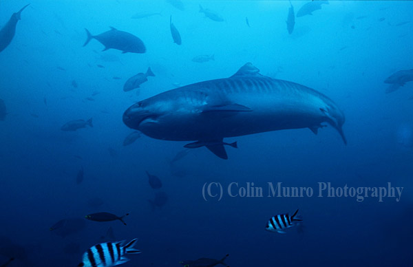
Large female tiger shark, Galeocerdo cuvier, known locally as Scarface, Beqa Lagoon, Fiji. Image MBI000479.

Large female tiger shark, Galeocerdo cuvier, known locally as Scarface, Beqa Lagoon, Fiji. Image MBI000479.

Large female tiger shark, Galeocerdo cuvier, known locally as Scarface, Beqa Lagoon, Fiji. Image MBI000479. Please email me, quoting this number if you’d like to license use of this image or purchase a fine art print.
Beqa Lagoon is often described as the World’s best shark diving location and I, for one, would not dispute that. I dived here with Rusi, Papa, Andrew and the team from Beqa Action Divers. I wouldn’t hesitate to recommend these guys, I couldn’t have asked for a more conservation-orientated team with a great laid back attitide. At the same time the whole operation was extremely professional, making the diving run as smooth as clockwork. Above water the location is simply stunning; lush forest and magrove bordering the Navua River which empties into the sheltered lagoon. These are not, however,the crystal clear waters of , say, the Bahamas. In Fiji it rains a lot. A lot! River waters pour in to the lagoon; rarely seriously reducing visibility but just enough to reduce light levels and create slightly gloomy effect at depth. In my opinion this rather adds to the atmosphere of the place; a big tiger or bull shark appearing out of the gloom is somehow more impressive than one cruising across a bright sunlight seabed. The key location for bull sharks and tigers is near the outer edge of the lagoon, where it meets the open ocean, dropping into very deep water indeed. This has the advantage that you are furthest from the freshwater inputs, so the water is much clearer. Bulls and Tigers patrol the lower part of the reef slope, rising up to the ledge at about 30 metres (100 feet) at which the deepest part of the dive is conducted. I was generously allowed to position myself directly behind Tubee, who had the unenviable task of hand-feeding feeding the sharks with large chunks of tuna. I thus had a perfect view as they cruised in, then swept past overhead (sometimes requiring a slight nudge to help them clear me).
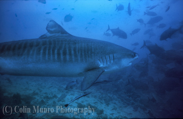
Close up of a large female Tiger Shark  known as;Scarface; swimming at around 30 metres depth, Beqa Lagoon, Fiji.  Image MBI000474.

Close up of a large female Tiger Shark known as 'Scarface' swimming at around 30 metres depth, Beqa Lagoon, Fiji. Image MBI000474.

Close up of a large female Tiger Shark known as Scarface; swimming at around 30 metres depth, Beqa Lagoon, Fiji. Image MBI000474. Please email me, quoting this number if you’d like to license use of this image or purchase a fine art print.
The tiger shark in these photographs is a lady known as scarface, due to the long scar running down from the right side of her jaw (the result of a fish hook). She is probably about 4-4.5 metres long (14-15 feet), so is a pretty big fish. She has been returning to the lagoon for several years, so is well known to the divers there. The first sign of her imminent appearance was the moving away of the bulls as they became aware of her presence; she then glided in to view, making a couple of circles to inspect the scene before deciding to head for the food. Although she has an impressive sense of smell her eyesight is not great; so provided you don’t move too much like food, or smell like food (slightly tricky when the water is full of tuna flakes) then you’re pretty much okay.
Large tiger shark, Galeocerdo cuvier, swimming towards diver, Beqa Lagoon, Fiji. Image MBI000486.

Large tiger shark, Galeocerdo cuvier, swimming towards diver, Beqa Lagoon, Fiji. Image MBI000486.

Large tiger shark, Galeocerdo cuvier, swimming towards diver, Beqa Lagoon, Fiji. Image MBI000486. Please email me, quoting this number if you’d like to license use of this image or purchase a fine art print.
Large female Tiger Shark, Scarface, swimming at around 30 metres depth, Beqa Lagoon, Fiji. Image MBI000476.

Large female Tiger Shark 'Scarface' swimming at around 30 metres depth, Beqa Lagoon, Fiji. Image MBI000476.

Large female Tiger Shark, Scarface, swimming at around 30 metres depth, Beqa Lagoon, Fiji. Image MBI000476. Please email me, quoting this number if you’d like to license use of this image or purchase a fine art print.
I took these shots on film, my last serious trip underwater with a film camera. The plus side is they produced huge images (20+megapixel images). The down side was I only had 100iso film and so was really struggling with light; even with a fast, wide prime lens (20mm) I was still down at 15th of a second shutter speed thus had to be pretty steady to get useable shots. Just to add to my problems, the auto-manual focus switch on my housing stopped working, leaving me stuck in autofocus. In such low light, low contrast conditions the autofocus was hunting like crazy. After losing a couple of perfect shots due to the camera failing to focus in time I resorted to the technique of waiting until a shark was approaching, deciding on the distance I was going to take the pic, then turning and pointing the camera at some coral rubble by my side that was about the same distance, locking focus, then with shutter half depressed turning and shooting once the shark was close enough. Needless to say this drew some curious looks from my Fijian friends; why on earth was I staring at a lump of rock to the side of me when a big shark was heading straight towards me, but hey! It worked.
A large female tiger shark, Galeocerdo cuvier, cruising near the seabed, beqa lagoon, Fiji. Image No. MBI000484

A large female tiger shark, Galeocerdo cuvier, cruising near the seabed, beqa lagoon, Fiji. Image No. MBI000484


I plan to follow this up with a couple more blogs on other shark species found at Beqa. Watch this space.

Skye Bridge, Kyle of Lochalsh, Northwest Scotland.

Skye Bridge, Kyle of Lochalsh, Northwest Scotland.

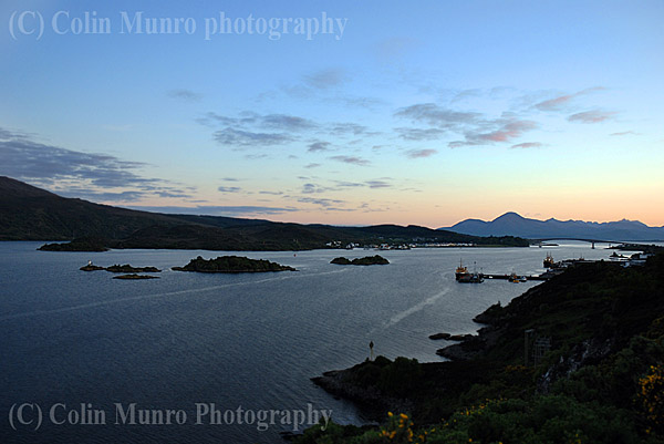
Skye Bridge, Kyle of Loch Alsh at sunset, looking across the Isle of Skye.

Skye Bridge, Kyle of Loch Alsh at sunset, looking across the Isle of Skye..

Skye Bridge, Kyle of Loch Alsh at sunset, looking across the Isle of Skye. Image MBI000901. Please email me, quoting this number if you’d like to license use of this image.
The Skye Bridge, Kyle of Lochalsh, is simultaneously one of the most impressive and contentious feats of recent engineering in Scotland. Completed in 1995, it sparked much debate about how it would change the nature of Skye now it was possible to drive there. More heated debate arose over the much hated toll to cross the bridge. It was described by some as ‘the only place you could get mugged and then receive a receipt’. The toll was abolished in 2004. Crossing to and from the mainland is now free. The village of Kyleakin lies on the Skye side of the bridge, with the small islet of Eilean Ban forming a stepping stone roughly mid-way across. Both locations featured heavily in the life of Gavin Maxwell, and were made famous in the book ‘Ring of bright water’. The island now belongs to the Eilean ban Trust, a joint project between the Born Free Trust and local communities. The Eilean Ban lighthouse can be seen in the last picture.
Loch Alsh at sunset, looking west towards the Kyle of Lochalsh and the Skye Bridge. Image MBI000902.

Loch Alsh at sunset, looking west towards the Kyle of Lochalsh and the Skye Bridge. Image MBI000902.

Loch Alsh at sunset, looking west towards the Kyle of Lochalsh and the Skye Bridge. Image MBI000902. Please email me, quoting this number if you’d like to license use of this image.
Skye Bridge and village of Kyleakin on the east coast of the Isle of Skye. Image MBI000903.

Skye Bridge and village of Kyleakin on the east coast of the Isle of Skye. Image MBI000903.

Skye Bridge and village of Kyleakin on the east coast of the Isle of Skye. Image MBI000903. Please email me, quoting this number if you’d like to license use of this image.