Leaving harbour at sunset. Crosshaven, County Cork, Ireland. Image No. MBI000943
walking along the harbour edge just before sunset on a warm evening, late summer, I watched a small yacht motor out, sails not yet raised, as it headed towards the Atlantic. Crosshaven harbour on the west coast of Ireland. Crosshaven is a stop-off point for many yachts heading around the wild west coast of Ireland, or crossing the Atlantic. A high resolution version of this image is available on my Photoshelter site (see link on right) within my sunrise and sunsets at sea gallery. If you would like an art print or to licence use of the image please email me.
Pirogue fishermen at sunset, Senegal, West Africa Image. MBI000914
Fishing canoe (pirouge) being landed at sunset, Senegal. Image MBI000914. Please email me, quoting this number if you’d like to license use of this image or purchase a fine art print.
A wooden fishing canoe returns from a day at sea, and men haul the boat and engine up the sandy beach as the sun sets. M’bour, Senegal.
Egyptian fishing boat at sunset, Eastern Mediterranean Sea. Image MBI000912.
Fishing boat at sunset, Eastern Mediterranean, off Egypt. Please email me, quoting this number if you’d like to license use of this image or purchase a fine art print.
I spend a couple of weeks working off in the eastern Mediterranean Sea, a few miles off the Nile delta, a while back. It was mid-winter, and we spent much of the time dodging gales. Although we were in a fairly substantial boat, waves piled up high in the shallow waters off the delta, so work was completed in brief sorties, then running back to port with four or five metres waves chasing us. When the sea was calm however, it was absolutely beautiful, with the most stunning sunsets. Calm weather also brought out large numbers of fishing trawlers. At one time I counted twelve trawlers all within sight of us; it seems highly unlikely that such fishing is sustainable and indeed I saw precious little catch when nets were hauled. As the sun set all nest were hauled and the boats headed back to port leaving us with the sea to ourselves until the sun rose again. I watched this boat inch past the dipping sun, with an almost blood red sky as a backdrop. There has been vistually no editing to this image – the sky really did look like that. Sometimes you have to really work to get great pics, and sometime you just need to be there.
M’bour, Senegal. Fishermen haul a small fishing pirogue (wooden canoe) up on to the beach at sunset.
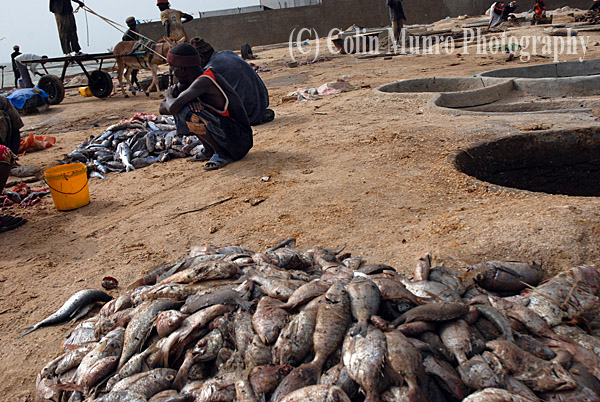
In November 2008 I spent two weeks in Senegal, living in M’bour, a dusty transit stop and fishing port halfway between Dakar and the Gambia. I spent this time getting to know the fishermen, going to sea with them, learning how they worked, the risks they took travelling up to 20 miles offshore in leaky open canoes without so much as a compass to guide them. I learned how they spent days at sea in tiny canoes, sleeping in the bottom of them, risking storms or being swept out to sea. As there canoes have no lights they also run the risk of being mown down by trawlers at night. Many do lose their lives each year, but economic pressures are causing a growing number of young men to turn to fishing. This brings its own problems; the fishery is poorly documented, but anecdotal reports suggest this is having a significant impact on stocks of some species. Robust data is hard to come by, given the unregulated nature of this fishery, but the Senegalese Directorate of Marine Fisheries estimated that in 2004 a little over 6000 such canoes were operating along the coast of Senegal. The main species caught are small sardinella (Sardinella aurita and S. maderenis) and horse mackerel (Trachurus trachurus). In 2008 the fishery off M’bour and nearby Joal Fadiouth was considered over-exploited (source FAO,Fisheries Circular No. 1033, 2008).
Our fishing canoe, or pirogue, being lanched off beach on wooden rollers, M’bour, Senegal.
Now fully laden, our ancient outboard is securely fastened with bailing twine. Note the well balanced ice box perched toward the stern of the canoe.
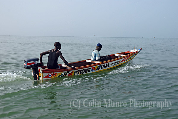
M’bour, Senegal. Two Senegalese fishermen head out to sea in a small pirogue (traditional wooden canoe).
I spent a day at sea on one of these tiny boats. Simply making it through the surf was quite an acheivement; the boat had no ballast and was so top heavy, due to ourselves and the large box of ice we were carrying, that we appeared in imminent danger of capsizing. Fortunately we shipped quite a lot of water quite quickly during a rather sketchy launching. This few inches of seawater inside our boat at least gave us some stability by providing a little ballast, albeit not a recommended way of doing so. Powered by an ancient 15hp, 2-stroke Yamaha outboard engine secured by bailing twine to the transom, we headed out to sea for about three hours, by which time I estimated we were about fifteen miles offshore. For the first 30 minutes or so we saw a few other boats, but they quickly dispersed in different directions; soon we were alone. We had set off in a grey haze that quickly enveloped the land. The sun became a slightly brighter glow penetrating the haze. Both sea and sky were otherwise quite featureless. As we motored steadily along, I watched with growing alarm as the sky changed, growing dark and heavy, with a stiffening breeze springing up. Maybe two hours out we came upon another canoe, similar to ours. This one was drifting aimlessly as their equally ancient outboard engine had died. The delight at our arrival shown by the three fishermen onboard quickly turned to consternation when, Pape, our boats owner and skipper, offered not to towed them to back to shore but to a point at sea where they ‘had a better chance of being spotted’ by a home-bound canoe. So for half and hour or so we towed them further out to sea (or at least it seemed that direction to me) before leaving them to anchor on what appeared an equally deserted and featureless location.as was the spot we had towed them from. We never saw them again. I rather hope this meant that they had indeed been towed ashore.
Our unhappy fishermen drop anchor and start their wait for a passing vessel after we tow them to a ‘better’ location.
At one point Pape asked me which direction I thought M’bour lay. With no visual clues to guide me I based my guess on the heading I thought we had set off on, and pointed on the reciprocal bearing. Apparently I was almost 180 degrees out. I asked Pape how he could tell, with such confidence, with no compass or electronic aids. The wind direction he informed me. So, I enquired cautiously, does it always blow from the same direction this time of year? No, he cheerfully informed me, sometimes we get lost. I rather wished I hadn’t asked.
Eventually we arrived at the fishing grounds. What exactly identified them as ‘the fishing grounds’ I have no idea. There were no surface features; nothing on the horizon. Hooks were baited with little, frozen prawns from our icebox and handlines set. A small stove was fired up in the middle of the canoe and sugary tea the colour and consistency of stockholm tar brewed. A cup was passed around from which we all took small sips; more than this would most likely have resulted in irreversible damage to my intestines. Tea was supplemented by joints also passed around. Tea, reefers and small amounts of rice and peanut porridge (gosi) were pretty much all the crew had to survive on apart from whatever they caught. Around two hours passed, in which time we had caught maybe a dozen fish, mostly sardinella, horse mackerel and a few bigeye grunt (Brachydeuterus auritus). Barely enough to feed us at sea, let alone provide a wage for all three fishermen. Around four in the afternoon, by which time the chop on the sea had risen significantly and little whitecaps had started to appear, we finally decided to head back inshore. Much to my relief, Pape’s sense of direction proved accurate.
The sun was setting when we finally reached M’bour, and there have been few occasions when I’ve been quite so pleased to step on to dry land. Pape and his crew would probably go to sea again tomorrow, maybe staying out for one or two nights this time. I thought that night of the meagre catch we returned with after a day at sea, of the broken down canoe we had come across and of the stories Pape had told me of getting caught in a storm and drifting helplessly for three days before sighting land. Overfishing is a massive problem on the West coast of Africa. Much of this problem is actually due to poorly regulated fishing by large trawlers from outside Senegal: Russian, Korean, Japanese, Chinese and European boats. It has been estimated that a large trawler will, on one good day, catch as much as fifty pirogues will in a year. Vessels are licensed by the Senegalese Government who argue that if they don’t sell licenses then neighbouring countries will; stocks may still suffer and Senegal will lose valuable revenue (Grégoire Allix, le Monde/Worldcrunch, 2011). What is a matter of concern about the long term effects of overfishing for us in the West can be a question of survival for some on the coast of Senegal.
One of our crew hand lining for fish at the ‘fishing grounds’, waiting for a bite.
Fish salting pans, M’bour, Senegal.
View more of my images of Senegal and from other regions of the World here at my main Colin Munro Photography website.
Skye Bridge, Kyle of Loch Alsh at sunset, looking across the Isle of Skye..
Skye Bridge, Kyle of Loch Alsh at sunset, looking across the Isle of Skye. Image MBI000901. Please email me, quoting this number if you’d like to license use of this image.
The Skye Bridge, Kyle of Lochalsh, is simultaneously one of the most impressive and contentious feats of recent engineering in Scotland. Completed in 1995, it sparked much debate about how it would change the nature of Skye now it was possible to drive there. More heated debate arose over the much hated toll to cross the bridge. It was described by some as ‘the only place you could get mugged and then receive a receipt’. The toll was abolished in 2004. Crossing to and from the mainland is now free. The village of Kyleakin lies on the Skye side of the bridge, with the small islet of Eilean Ban forming a stepping stone roughly mid-way across. Both locations featured heavily in the life of Gavin Maxwell, and were made famous in the book ‘Ring of bright water’. The island now belongs to the Eilean ban Trust, a joint project between the Born Free Trust and local communities. The Eilean Ban lighthouse can be seen in the last picture.
Loch Alsh at sunset, looking west towards the Kyle of Lochalsh and the Skye Bridge. Image MBI000902.
Loch Alsh at sunset, looking west towards the Kyle of Lochalsh and the Skye Bridge. Image MBI000902. Please email me, quoting this number if you’d like to license use of this image.
Skye Bridge and village of Kyleakin on the east coast of the Isle of Skye. Image MBI000903.
Skye Bridge and village of Kyleakin on the east coast of the Isle of Skye. Image MBI000903. Please email me, quoting this number if you’d like to license use of this image.