Blue Maomao Arch, Poor Knights, new Zealand. Schooling blue maomao congregate along the sheer walls of the arch
Photography is painting with light, but it’s equally the absence of light. It’s about creating a mood, an emotional response, with the balance of light and shadow; it’s using shadow to draw one’s eye to the light. Technically, this image may be too dark, it’s ceratinly not evenly lit. But that’s the point; what’s aesthetically interesting is rarely what’s technically perfect. Blue Maomao Arch, Poor Knights, new Zealand. Schooling blue maomao (Scorpis violacea) congregate along the sheer walls of the arch, feeding on the plankton rich currents that are entrained and accelerated through between the walls of this long tunnel.
This image was shot in early 2020. I used a Full frame Nikon camera, 20mm Nikon lens, in an Aquatica housing. Although I had a flash (strobe) attached to the camera I chose not to use it for this shot, rely purely in the natural light penetrating the arch.
In you enjoyed this blog please consider subscribing. You can do this using the simple subscribe form.
Fine Art Landscape and Wildlife Prints
Some of the framed canvas wrap prints on my website. You can also check out my fine art prints and posters.
With a little spare time right now I’ve begun re-organising my stock image library, sorting through older folders that were created before my current system was created. This is something of a daunting task; from 2014 alone, I have around 4 terabytes of images. Still, it refreshes my memory of many places that have become a little hazy in my mind.
A young yaku sika deer, stag Cervus nippon yakushimae, resting in a forest glade, Yakushima Island, Japan.
Occasionally I come across images I’d almost forgotten about. This is a yaku sika deer, in a forest on Yakushima Island. Yakushima, Kagoshima Prefecture, is a small, mountainous island, less than 30km across, in Southern Japan. It forms part of the Ryukyu (Nansei) island chain that separates the East China Sea from the open Pacific proper. It’s known for the beautiful cedar forests that cover much of the island. Yaku sika (Cervus nippon yakushimae) are a subspecies of Sika deer endemic to Yakushima Island. They are relatively unafraid of humans, they haven’t been hunted on the island for over 50 years, allowing me to get fairly close to this young stag resting in dappled sunlight in a forest glade.
n you enjoyed this blog please consider subscribing. You can do this using the simple subscribe form.
Fine Art Landscape and Wildlife Prints
Some of the framed canvas wrap prints on my website. You can also check out my fine art prints and posters.
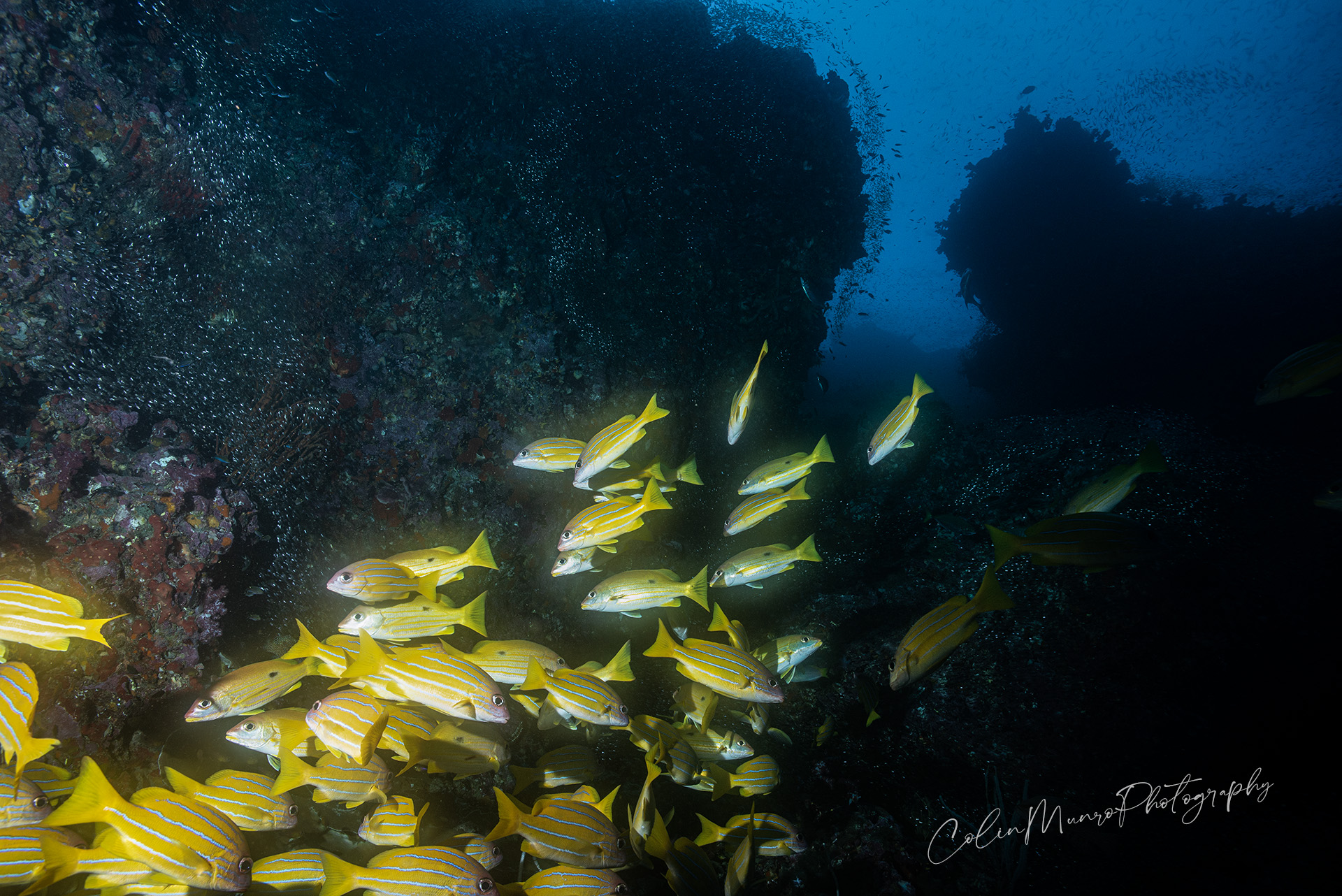
Five-lined snapper (Lutjanus quinquelineatus) aggregate under an overhanging wall, Similan Islands, Andaman Sea.
Five-lined snapper (Lutjanus quinquelineatus) aggregate under an overhanging wall, Similan Islands, Andaman Sea. There are a number of closely related, blue lined snapper, that occur, mostly on coral reefs, in the tropical and subtropical Indo-Pacific. The common bluestripe snapper (Lutjanus kasmira) and the Bengal snapper (Lutjanus bengalensis) all have similar patterns and overlapping ranges, including the Andaman Sea. Differentiation is not always easy, and the academic literature has at times been confusing. Modern genetic techniques are helping clarify relationships, to a degree at least. Perhaps a more important question, and one harder to answer, is why very similar species that appear to occupy similar ecological niches, and with broadly overlapping ranges, actually exist. What is the driver for speciation, genetic and reproductive isolation? This is a harder problem to investigate because studying the behaviour of highly mobile species inhabiting deeper waters on offshore reefs is difficult, time consuming and expensive. Colour patterns involving horizontal stripes is a feature that has evolved separately in many species of fish, especially schooling fish (e.g. fusiliers, snapper). Various hypothesis have been proposed as to why horizontal stripes might be advantageous. It may be difficult for a potential predator to identify individual fish in a tightly formed school, all horizontally striped, as the stripes may be more obvious than the outlines of individual fish (often called the confusion effect). It may be difficult to judge the speed of horizontally striped prey as swim past if they are swimming in the same orientation as the stripes are aligned. Others have suggested that that stripes help co-ordinate movement in schooling fish; as the school changes direction so does the orientation of the stripes, providing a strong visual cue. Zebrafish are used in many laboratory studies, partly due to their ease of rearing and fully sequenced genome. Working with striped and unstriped zebrafish morphs, scientists found that striped individuals showed the strongest tendency to form schools, and would preferentially form schools with individuals that most closely resembled themselves. How much of this behaviour transfers from zebrafish, fish that inhabit the shallow streams, ponds and rice paddies of South-east Asia, to large schooling fish on deep, offshore reefs. Who knows? Deeper offshore reefs don’t easily lend themselves to manipulative experiments where confounding factors can be controlled. Observational studies can be conducted in large public marine aquaria, but extrapolation to truly natural behaviour must be done with care. It is likely that much of our understanding of behaviour and interactions in such difficult habitats will continue to be opportunistic, conducted from recreational dive boats, with some coming from big-budget natural history documentary filming, such as the BBC’s Blue Planet series, where the money and expertise exists to overcome some of the major logistical problems. There is so much we don’t know about the how and why of the ecology of such reefs, and that situation is unlikely to change anytime soon.
In you enjoyed this blog please consider subscribing. You can do this using the simple subscribe form
I write these posts primarily because I enjoy doing so. They’re free to read, and if you enjoyed reading this one I hope you’ll continue to read them. I have no plans to paywall any of them. If you feel like you want to support my time input, well … I do like good coffee.
Photography and video, free-diving, in shallow surf, for me at least, presents some of the most challenging situations in photography.
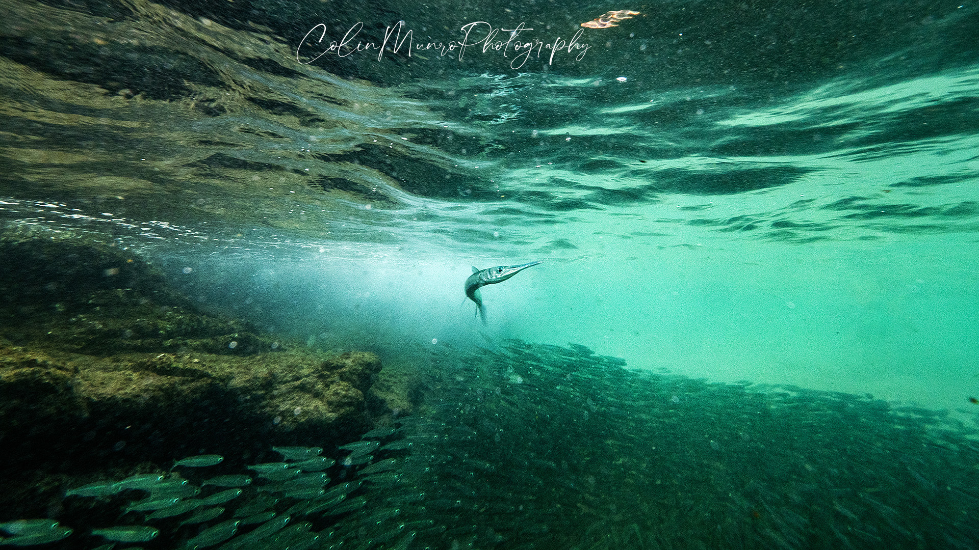
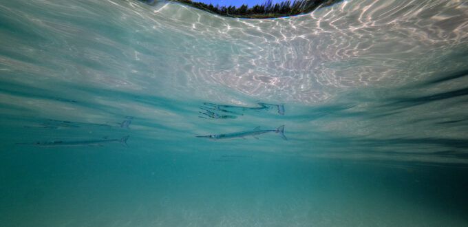
A crocodile needlefish (Tylosurus crocodilus) menaces a school of sardines.
The visibility is generally terrible, rarely more than two metres and often less than one. The waves and shallow water make staying underwater difficult unless massively overweighted (which brings its own problems when you need to breathe). Waves will unexpectedly sweep you up on to oyster and barnacle covered rocks – which tend to leave you looking like you’ve had a fight with a cheese grater, or worse still, may smash the plexiglass dome port of the camera housing. Passing waves occasionally pick up and then dump a truck-load of sand, reducing visibility to zero, to be followed by a washing machine of bubbles as the wave breaks.
Waves sweep sand up of the seabed, depositing them in a rain of bubbles and glittering sand particles as they crash against the rocks.
In these conditions auto-anything becomes pretty useless. Exposure is all over the place and the water is full of all sorts of crap flying past you (or you flying past it). So manual exposure and manual focus is really the only way to obtain useable images. Underwater flash cannot be used either; with so much suspended sand in the water that would act like tens of thousands of small mirrors bouncing light back into the camera.
Miniature sand storms swirl around the rocks as the waves sweep past.
But despite all that, the rewards can be well worth it. Often, just in the shallows is where the action is. Especially close to sunset. These are schooling sardines, swirling around in around a metre to a metre and a half depth, just of the shore, just as the sun was touching the horizon. Crocodile needlefish (Tylosurus crocodilus) cruise around the edges of the school like hunting dogs, looking to pick of a straggler that gets separated from the main body, whilst small schools of small-spotted darts (Trachinotus baillonii) zip in and out picking up planktonic crustaceans and fish fry.
At sunset, sardines sweep past across submerged rocks, only centimetres below crashing waves.
Photographing in these conditions will never yield the clean, sharp, colourful images so loved by advertisers and photographers alike, but they do record a reality not often featured in underwater photography magazines or glossy brochures. They also, I hope, capture the atmospheric look of turbid, energetic waters. For me, if I get in the water and the fish are there (there are times I get in the water, buffeted by waves, but see little) and I get out of the water with no major lacerations and my camera gear still intact, then the evening was a success. If I end up with useable images, that’s a bonus.
In you enjoyed this blog please consider subscribing. You can do this using the simple subscribe form.
Fine Art Landscape and Wildlife Prints
Some of the framed canvas wrap prints on my website. You can also check out my fine art prints and posters.
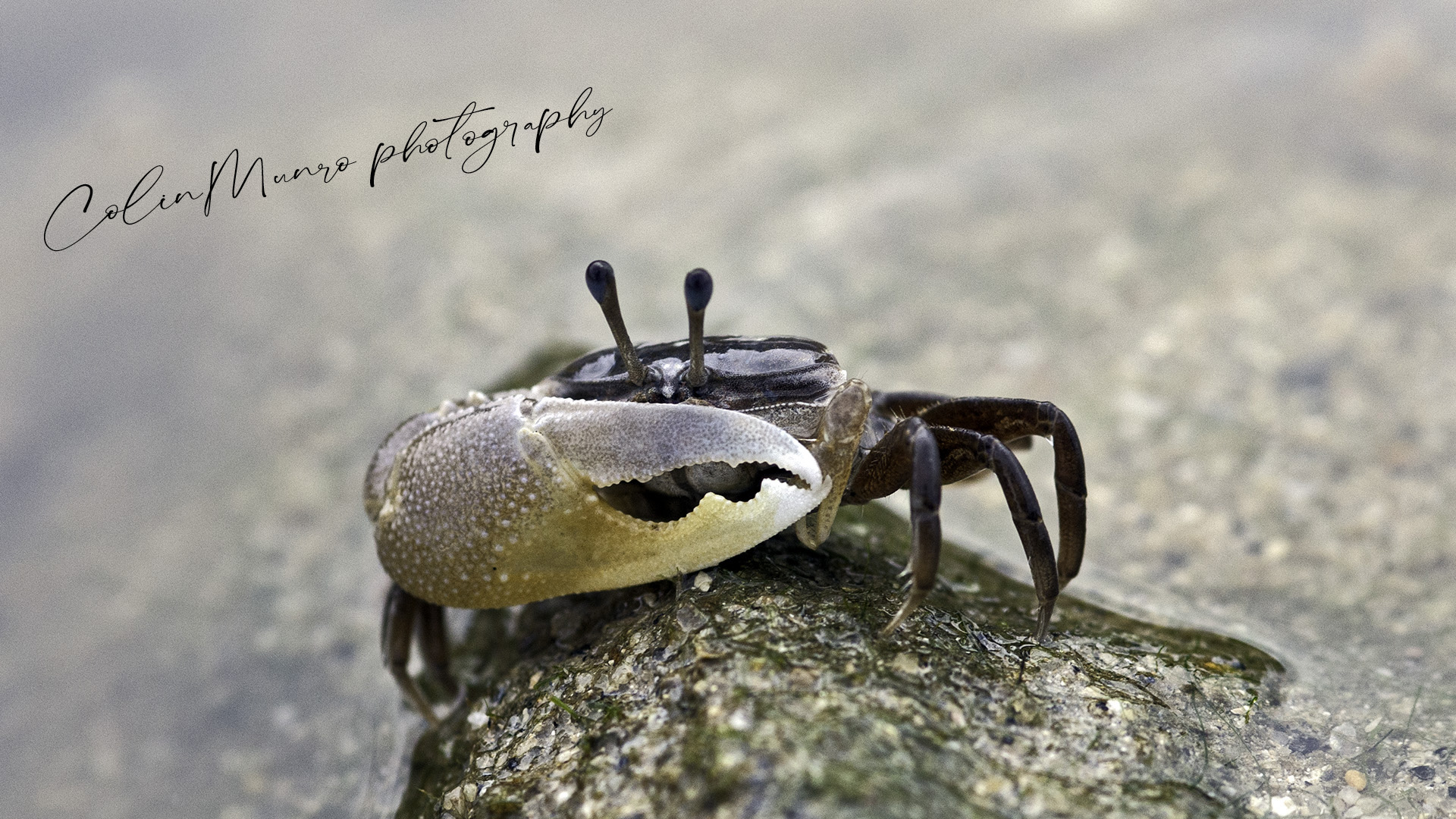
Fiddler crabs belong to the Ocypididae family of crabs. These are the stalk-eyed crabs mostly found in the intertidal shores of tropical and temperate seas. They get their name from the males having one claw much larger than the other, which they often wave in the air. This waving of the large claw, and the relatively tiny other claw, makes them look rather like they are playing a violin or fiddle, think maybe the fiddle player in a Galway pub, after 12 pints of Guiness (other stouts are available). Why do they wave their big claws in the air? Well I’ll get to that in a bit.
A male fiddler crab, Gelasimus (Uca) vocans, where the much larger claw can be clearly seen. Kamala Beach, Phuket, Thailand
Where are fiddler crabs found?
Fiddler crabs feed by eating sand and mud, and sifting out the organic material. Thus they tend to be found on the margins of mangrove forests and along muddy estuaries and on beaches where rivers enter the sea. Anywhere on the intertidal where there is significant input of organic material. On Kamala Beach, in Phuket, Thailand, where I took these images, fiddler crabs are mostly found at the southern end of the beach. This is because the local klong (the thai word for a canal, or sometimes a small river) flows into the sea here. The klong is rich in organic material, mostly leaf litter and organic material leeched out of the surrounding earth, particularly so during the rainy season, when the klong runs red with suspended soil. When the flowing water of the klong collides with seawater, two forces come in to play. Firstly, the speed of the flow will decline, causing tiny organic particles to slow down, and then sink and settle. The second factor that comes in to play is that salt (in seawater) causes organic material to clump together into larger lumps (scientists love fancy terms, so this is termed flocculation). This flocculated organic material will also then tend to settle out faster. But I’m digressing here somewhat. The end result is that lots of organic material tends to settle out where rivers (or in this case, a klong) hit the sea, producing over time a fine muddy sand that is extremely rich in organic material. In Kamala Beach this contrasts sharply with the northern end, where there is little organic input. The northern end is also more exposed to the south-westerly monsoon winds of the rainy season. This drives more energy on the beach, creating bigger waves, and so washing away any finer organic material deposited on the beach and leaving only larger sand grains and shell fragments. This produces a beautiful white sand loved by tourists, but it’s relatively sterile, so not loved by fiddler crabs. This also helps explains why surfing happens mostly at the northern end of the beach and why local fishermen chose to anchor their boats at the southern end.
Fiddler crabs foraging. What do they eat?
A short, 30 second clip showing fiddler crabs feeding on Kamala Beach. It also illustrates the difference between females and males.
As you can see in the video, the small claws are used to scoop up handfuls (er ..clawfuls) of wet sediment into the crab’s mouth. Here, jaw appendages called maxillipeds sort and retain organic material: diatoms, bacteria and other microscopic organisms. The maxillipeds are covered in bristles (called setae) with spoon-shaped ends. These separate food particles from the inorganic sediment. Now here the females have a huge advantage; they can use both claws to scoop sediment into their mouths (and they do so with the enthusiasm of a toddler given chocolate). The males however, can only use they’re smaller claw. The larger one is pretty much useless for anything other than .. well, waving around really.
A male fiddler crab using it smaller, more dextrous, claw to shovel sand into its mouth. its larger claw is useless for this task.
So this brings us back to the perplexing question. Why do males have this one larger claw when it is clearly such an impediment to feeding? The answer is two-fold; to attract females to mate, and to fight off other males.
Mating is a complex and tricky issue among fiddler crabs. Males have been found to employ a variety of techniques to try and persuade females to mate. These have been termed ‘gambits’ by scientists studying them. They range from the distinctly romantic ‘standard gambit’, where the male suitor will unseal his burrow early, as the tide recedes, and position himself outside a female’s burrow, carrying a bunch of flowers (okay I made that last bit up). When the female emerges he will engage in some gentle stroking of her shell, before grabbing hold of her and turning her around. If the female decides she likes him she will allow him to position her. If she decides he’s going too far on a first date she will scuttle back down into her burrow.
A male fiddler crab wades through running water where the klong flows across the intertidal flats.
A short clip of a male fiddler crab emerging from hiding
With their big, stalked eyes, fiddler crabs have pretty good, 360 degree vision. They will often use these rather like periscopes, sending up one or two eyes above the sand or water surface to recce the terrain before venturing out of hiding. I’ve written more about the crab stalked eyes in my blog about hermit crabs, you can read it here.
Fiddler crabs will often send up one eye – rather like a periscope – to check for any potential threats before venturing out of hiding.
In you enjoyed this blog please consider subscribing. You can do this using the simple subscribe form.
Fine Art Landscape and Wildlife Prints
If you enjoyed this article why not check out my other blogs. I write about travel, the environment, marine biology, diving and wildlife. You may also want to check out my photographic prints. These can be viewed on my main site www.colinmunrophotography.com and include landscapes from around the World, people of the World, marine life and other wildlife. The prints are only available through my website, each one individual processed and made to order. This includes fine art giclee prints, limited edition prints and canvas wraps. I use only the best, carefully selected print houses employing the finest papers and printing processes to ensure image fidelity and longevity.
Some of the framed canvas wrap prints on my website. You can also check out my fine art prints and posters.
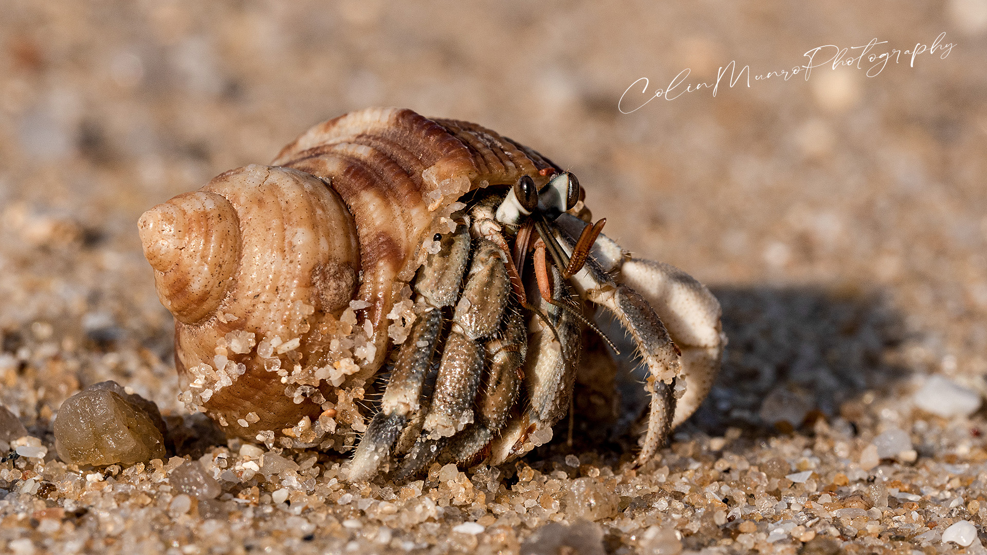
Many years ago, my undergraduate thesis was on hermit crabs, and I’ve had a fondness for them ever since. Hermit crabs are the great survivors. They live in some of the harshest environments, pounded by surf, exposed to searing heat and desiccating winds, and somehow able to find sustenance on the most barren of beaches. Possibly the most common species seen around the shores of Phuket is the land hermit crab Coenobita rugosus.
A land hermit crab, Coenobita rugosus, walking just above the waves at high tide, on a beach in Phuket.
How many species of hermit crab are there?
There are thought to be over 800 species of hermit crab. Fifty five different species of hermit crab have been recorded from Thailand’s shores and surrounding seas (McLaughlin, 2002). This can make indentification tricky. Hermit crabs fall in to three distinct families: the Dioginedae, the Paguridae and the Coenibitidae. The coenobitids (like this guy, pictured above) are the real land hermit crabs, often venturing some distance from the sea. So if you are beach-combing in the tropics, they are the ones you are most likely to see.
How do you identify Coenobita rugosa?
In the tropics (and I’m primarily writing this about Thailand), any hermit crab found high up on the shore, at or above the high tide mark, or inland of this, is likely to be a Coenibita species. However, to complicate matters there are actually three Coenibita species found on Phuket shores ((McLaughlin, 2002; Bundhitwongrut et al., 2014) all occurring in more or less the same habitat. Tricky! These are C. rugosus, C. violascens and C. brevimanus. The best way to identify Coenibita rugosus is by looking closely at the top of the outside edge of the end joint of its left claw. A series of small, linear tubercles can be seen on C. rugosus, but not the other two species. Incidentally, it is thought that these tubercles are involved in generating sound. Land hermit crabs will ‘chirp’ by stridulating, that is rubbing body parts together to produce a sound (as cicadas and grasshoppers do).
A number of small, linear tubercles on the outside edge of the end of the left claw distinguishes Coenobita rugosus from the other Coenobita species occuring on Phuket shores.
How do land hermit crabs breathe when out of the water?
A big problem for any animal primarily designed to live in the sea is how to breathe in air. The gills used by fish and most aquatic invertebrates to adsorb oxygen underwater don’t work very well on dry land. The gills of crabs are composed of many very thin plates (lamellae) each with a central shaft rather like a feather. Oxygen is absorbed and carbon dioxide expelled across the surface area of these plates. However, when out of water, these lamellae collapse directly on top of one another, greatly reducing the available surface area for gas exchange. Most coenobitids (such as C. rugosus) have adapted by having much smaller gills, they spend little time in the water, and with these gills somewhat adapted for breathing air. Around the gill is what is known as a branchiostegal lung. This is essentially gill tissue that is more adapted to absorb oxygen from air rather than water. Branchiostegal lungs are not unique to hermit crabs, other crabs that spend significant amounts of time out of the water, such as fiddler crabs, also possess them. Such are the wonders of evolution, each group has developed a different design of branchiostegal lung; there are many different ways to acheive the same end it seems. The coenobitid hermit crabs have also developed a second method for gas exchange. Protected inside their mollusc shell home, the upper surface of their thin-skinned abdomen has become highly vascularised, with gas exchange taking place directly through the skin. To further improve this the skin has become deeply wrinkled, increasing surface area. This has been termed an abdominal lung.
What do land hermit crabs eat?
What do they eat? Pretty much anything. They consume quite a lot of plant material, including fallen leaves such as acacia and beach cordia. They are also partial to a bit of carrion, crabs or fish washed up. Cannibalism too, is on the table if the opportunity presents. Smaller C. rugosus hermits need to be wary of getting too close to their bigger brothers.
Senses
The current evidence suggest that Coenobitid hermit crabs primarily use their sense of smell for food detection. The studies also suggest that their ability to detect smell was limited to water soluble molecules, and greatly enhanced in humid conditions. Here in Phuket a lack of humidity is rarely a problem!
The stalked eyes of Coenobita rugosus. Their elongated shape can be clearly seen. The dark, elongated shape of the pseudopupil can also be seen.
Many hermit crabs also have pretty good eyesight. This is probably more related to defense and avoiding predators than feeding. Crabs have compound eyes; each eye is actually made up of a great number of hexagonal light sensors, each with their individual lens and cornea. These individual light sensors are known as ommatidia. Like fiddler crabs and ghost crabs, Coenobita rugosus and its relatives have eyes on stalks and eyes that are rather longer than they are wide. This vertical stretching of the eyes means that the angular change between each individual ommatidia is less in a vertical plane than in a horizontal, thus they have better optical resolution for objects, and changes in light, vertically than horizontally. This is probably an adaptation for predator detection; most predators likely to be bigger and casting a shadow or darker shape from above. If you look carefully at the eyes you will notice what appears to be a dark stripe near the centre of each eye. This is known as the pseudopupil. It represents the ommatidia that are more or less pointing straight towards you, and thus no light is being reflected back. As explained above, the angular change between ommatidia is less vertically than horizontally, so the pseudopupil has the shape of a vertical line. In humans, and other vertebrates, the pupil contracts or expands as light levels change, allowing more or less light into the eye. But crab eyes don’t have real pupils; this begs the question, how do they deal with changing light levels? The answer, in fiddler crabs at least, has been discovered only recently. When light travels through the lens of an ommatidiait is focussed on a column of dense, tiny finger-like projections (microvilli) containing photosensitive molecules. For crabs that are active both in bright sunlight and around dusk, these microvilli change size, growing or shrinking, and so dramatically altering the amount of light they capture.
Fine Art Landscape and Wildlife Prints
If you enjoyed this article why not check out my other blogs. I write about travel, the environment, marine biology, diving and wildlife. You may also want to check out my photographic prints. These can be viewed on my main site www.colinmunrophotography.com and include landscapes from around the World, people of the World, marine life and other wildlife. The prints are only available through my website, each one individual processed and made to order. This includes fine art giclee prints, limited edition prints and canvas wraps. I use only the best, carefully selected print houses employing the finest papers and printing processes to ensure image fidelity and longevity.
Some of the framed canvas wrap prints on my website. You can also check out my fine art prints and posters.
Selected references.
Farrelly, C. A., and Greenaway, P., 2005. The morphology and vasculature of the respiratory organs of terrestrial hermit crabs (Coenobita and Birgus): gills, branchiostegal lungs and abdominal lungs. Arthropod structure and development, 34.
McLaughlin, P. A., 2002. A review of the hermit-crab (Decapoda: Anomura: Paguridae) fauna of Southern Thailand, with particular emphasis on the Andaman Sea, and descriptions of three new species. Phuket Marine Biological Center Special Publication23(2): 385–460.
Bundhitwongrut, T., Thirakhupt, K. and Pradatsundarasar, A., 2014. Population ecology of the land hermit crab Coenobita rugosus (Anomura, Coenobitidae) at cape Panwa, Phuket Island, Andaman Coast of Thailand.
I often see needlefish when snorkelling around the Andaman Sea shores of Western Phuket and Peninsular Thailand. Needlefish, or long toms as they are commonly known in Australia, are predators of (mostly) small fish; They inhabit surface waters where their long, slender form and silvery scales render them almost invisible until quite close. I generally encounter them hanging around the periphery of reefs, or cruising around piers, just beneath the surface, and sometimes in very shallow water, surfing in on small waves to where the water is only a few inches deep. They patrol these areas in small groups of up to a dozen or so, moving like hunting dogs, looking to sneak close enough to an unwary sardine or silverside to pounce. Usually they will suddenly launch themselves forward at speed into the school of small fish, hoping to grab one as they scatter. Off heron Island, on Australia’s Great Barrier Reef, they have been observed to launch aerial attacks; leaping clear of the water, to land amongst the unsuspecting school of bait fish. I’ve never personally observed this and as far as I know it’s never been recorded around Thailand.
A crocodile needlfish patrols the edge of a pier, looking for unwary sardines to form its next meal.
Needlefish have a reputation for being dangerous to swimmers and fishermen. While far from aggressive (they’re actually quite timid and tricky to approach close) there have been a number of injuries and indeed some fatalities caused by needlefish. The problem is that when needlefish feel threatened, they will often leap out of the water; long, low leaps, travelling at speed and covering some distance. I’ve seen speeds of 40 mph through the air mentioned, though I suspect this is little more than a guesstimate. With their long, thin needle-like jaws it’s easy to see how being unlucky enough to be stuck by one could cause serious injury. In November 2020, a Hawaiian man out sea canoeing found himself in the middle of 30-40 needlefish leaping out of the ocean. Several stuck his canoe, one puncturing straight through the fibreglass canoe hull. In Nha Trang, Vietnam, in 2014, a Russian tourist was swimming when she felt a sharp pain in her neck. She was rushed to hospital suffering partial paralysis. Emergency surgery removed fragments of needlefish jaw, and teeth, from around her spinal cord. Fortunately she made a full recovery. Though incidents can be very nasty they are also, thankfully, very rare. Fatalities are extremely rare, but do happen. In 2018 a young Thai cadet training with Thai navy special forces died after hit him in the neck during a military training exercise.
There are probably more incidents that go unrecorded; local artisanal fishermen are generally at much greater risk due to the amount of time they spend in the water or in small boats, especially at night. Lights, often used to attract fish, are known to attract or create panic in needlefish, causing them to leap out of the water. In Papua New Guinea, for example, where fishing at night from small wooden outrigger canoes is a very common occurrence, numerous injuries are recorded every year. The use of lanterns to attract fish appears to increase the risk. (You can read more about the outrigger canoes of Papua New Guinea in my blog here)
Should you be unfortunate enough to be struck by a needlefish while swimming or wading it is absolutely imperative that you get proper medical attention. Injuries to the arms or legs may seem minor, but the fish beaks can penetrate deep. Teeth and jaw fragments will also frequently break off, remaining un-noticed within the wound. In 2015, a passenger on a Caribbean cruise was struck on the nose by a needlefish while wading in waist-deep water. This left what appeared to be only a small wound that healed quickly. Three months later, after persistent nasal problems, a 39mm long fragment of needlefish beak was removed from the man’s sinus, the tip only 5mm away from the left frontal lobe of his brain. In 2013 a Japanese swimmer received treatment after being struck in the lower eyelid by a needlefish, the wound was cleaned and all fragments thought to be removed. Swelling persisted and a subsequent CT scan found two 25mm long fragments above his eye, which were then surgically removed. There is also a high risk of infection from such wounds, so treatment with broad spectrum antibiotics is normally recommended after any injury.
This may all make the seas sound a very dangerous place, but it’s worth keeping things in perspective. These events are rare. Lightning strikes kill thousands worldwide every year. Tens of millions go swimming or fishing in tropical waters every year and suffer nothing worse than mild sunburn. Maybe don’t go fishing at night in a small canoe, carrying a spotlight.
I took these photographs of crocodile needlefish (Tylosurus crocodylus) snorkelling off a beach just north of Phuket Island. I had been hoping to photograph the large schools of sardines that were hiding underneath the long concrete pier there. Unfortunately a plankton bloom coupled with windy conditions and a strong swell made that pretty much a non-starter. Visibility of less than three metres was not going to produce great images of large schools of fish. In addition, the low visibility and significant swell did not fill me with enthusiasm for diving down under the pier, the legs of which were covered in a thick blanket of razor-sharp oyster shells. I’d learned to my cost than a bump against those was not a pleasant experience. However, gazing down from the top of the pier I could see number of needlefish patrolling the edges and surfing in on breaking waves. So despite the unpromising sea conditions, and the fact that my camera was set up with a very wide-angle lens – not ideal for getting close to timid fish – I decided I was there now and so might as well get in the water.
The first picture was taken along the edge of the pier. I wanted to catch a needlefish in the light, but have the dark shadows under the pier behind it. This sounded straightforward, but, in reality, involved a lot of slow dancing around the edge of the pier, trying to get close, with the sun at the right angle whilst avoiding getting washed against the pier legs. I would carefully line up a shot only to have the fish disappear into the green haze. Eventually I got one that was acceptable.
A couple of crocodile needlefish cruise past me in shallow water.
The second shot was taken close in to the shore, in less than a metre of water. Here in the shallows the light levels were high, but plankton combined churned up sand to reduce visibility further still. Half a dozen needlefish continually moved in to the shore, then turned and circled back out, moving in and out of my vision as I bobbed in the waves. I switched everything to manual, including focus given the turbidity of the water, and concentrated on firing off shots as we, fish and I, warily waltzed around each other. After around 30 minutes I decided it was time to get out. The wind was increasing, and so were the waves. If I hadn’t got useable shots by then it wasn’t going to happen.
For more stories, made to order framed wall-art canvas wrap prints, fine art prints, posters, stock images and more stories, visit my main site: www.colinmunrophotography.com
colinmunrophotography.com
I write these posts primarily because I enjoy doing so. They’re free to read, and if you enjoyed reading this one I hope you’ll continue to read them (maybe even subscribe to my blog). I have no plans to paywall any of them. If you feel like you want to support my time input, well … I do like good coffee.
P.S I am now also on Substack
Stock Images
I license many of my images as stock images for use in journals, magazines, books, websites etc. A number of my images can be found and licensed on Alamy. You can also contact me directly to license images. I also have a great many images not currently online.
Adobe having been using AI, Artificial Intelligence, to speed up and improve aspects of their suite of software programmes for time now. The core of this is Adobe Sensei, Adobe’s in-house artificial intelligence technology. This has powered things such as predictive text titles in Adobe Premier Pro video editor, and content aware fill in Photoshop. Lots of technical terms that few of us fully understand are thrown around, e.g. neural networks, machine learning and deep learning. My own understanding is limited, so I’m not going to dwell on the details of the process. Suffice to say that machine learning, deep learning and neural networks are all essentially subsets of A.I., where software mimics (to a degree) the human thought process of analysing and learning. A.I. comes in to its own where impossibly large amounts of data or permutations are analysed at a speed beyond the capabilities of the smartest scientists. For us mere mortals, we can but gaze upon the results with similar awe and wonderment that neanderthals viewed comet trails and solar eclipses. So, going back to Photoshop’s Enhance, I’m going to concentrate on what we care more about. I’m going to look at the results. Adobe Sensi now comes to Photoshop’s Camera Raw processing software as ‘Enhance’, where, Adobe claims, it will produce more accurate rendering of edges and details, with fewer artifacts such as false colors and moiré patterns. Enhance also enables one to double the linear resolution of an image (i.e. 4 times the number of pixels) with, Adobe claims, superior results to previous methods. If so this can provide huge benefits. All that back catalogue of older images we took 10-15 years or so back, on 10 megapixel cameras, can be up-scaled to 40 megapixels. Images from crop sensor or micro four thirds cameras can be up-scaled to rival the latest full-frame DSLR images. Sounds too good to be true. But the bottom line is, how good are the actual results?
I first tried this out on a raw file from an older, micro four thirds camera, a 16 megapixel Panasonic GH4. I chose an image I had taken in Antarctica earlier this year. A picture of an old wooden whaling boat and whale bones, all lying in rather dirty, textured snow. The image had lots of detail and lots of texture in it, so I thought it a good test. For comparison, I processed the file in my normal way, using both Photoshop and Camera Raw adjustments. I then resampled the image in Photoshop, up-sizing to
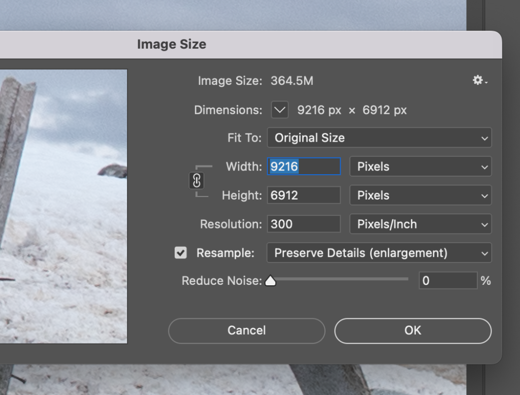
Whale bones and old wooden whaling boat wreck, Mikkelsen Harbour, Trinity Island, Antarctic Peninsula.
Up-sizing an image using Photoshop’s standard image resampling Preserve Details
To enlarge using Photoshop’s standard up-sizing we select (from the top-bar menu) image>image size, then in the dialogue box that opens set the units to pixels, make sure the resample box is checked and, in the adjacent drop-down menu, select Preserve Details (enlargement). Don’t worry about the resolution; this really only matters when printing an image or adding text.
Up-sizing an image using Photoshop’s A.I. based Enhance
For up-sizing using Enhance, we need to be using the Camera Raw plugin, which automatically opens as a separate window when we tray to open RAW images. Note that the Camera Raw filter in Photoshop (which can be used for JPEG and other formats) does not give you the Enhance option. (It is possible to change the Camera Raw settings in Preferences so that TIFF and JPEG are also opened initially in Camera Raw, but this is not the default). In any event, if we shoot in RAW it is always best to use RAW here in order to utilise the maximum amount of data.
The Enhance option can be seen near the bottom of the menu that appears after right-clicking on the image in Camera RAW.
Up-sizing an image using Photoshop’s image resampling Preserve Details 2.0
But hang on! There is a third option. Photoshop have also recently introduced Preserve Details 2.0. If you are using the latest version of Photoshop (at the time of writing 24.1.1) this should be turned on automatically, but if not then you need to go into Preferences and find Technology Previews. Preserve Details 2.0 is listed there, along with a check box to enable it.
The preserve Details 2.0 then appears in the Resample drop-down menu.
Comparing the results of all three methods
With all three methods I doubled the linear resolution of the image, up-sizing a 4608 x 3456 pixel image to 9216 x 6912 pixels or, to put it another way, increased the image size from 16 megapixels to 64 megapixels (a little rounding to whole numbers). This is a major increase in image size, so what does it actually look like? The only meaningful way to compare is to look at cropped sections of the image enlarged to 100%. First I chose a crop of an area with a fair amount of detail and hard edges to see how that would work out. The area I chose was a crop of the exposed ribs of the boat, including the nails sticking out, but it also includes areas of dirty, textured snow (it’s snow with penguin footprints, penguin poo and algae in it). The snow has some texture and colour variations but lacks hard edges and I was curious to see how each process dealt with that.
Preserve Details vs Enhance vs Preserve Details 2.0
Image crop at 100% using Photoshop’s Resample: Preserve DetailsImage crop at 100% using Photoshop’s A.I. based Enhance.Image crop at 100% using Photoshop’s Preserve Details 2.0.
I think it’s clear there there is more detail and crisper edges in the up-sized image using Enhance when compared to the standard Preserve Details. There’s also less colour fringing around the nails protruding from the ribs (less, but not absent). The texture of the wooden ribs is markedly muddier using Photoshop’s standard resampling. Preserve Details 2.0 shows distinct improvement over the standard version and is probably about midway between standard and Enhance when considering these two aspects. However it’s not all positive for the A.I. based Enhance. The added detail in the wood also clearly contains non-real artifacts created in the up-scaling, including noticeable flecks of false colour. Some of this could be removed in further processing, but possibly at the expense of some of the detail gained. These artifacts become much more obvious when one looks at the snow in the bottom right of the image. In an attempt to add detail to the enlarged image Enhance has created non-real repeating patterns than show up as dark, sinuous ‘spaghetti’ lines that are slightly fringed with green and magenta. This creates a quite false look to the snow when viewed at this magnification. A.I. based image enhancement works by looking at very large numbers of similar images and so ‘learning’ what certain features look like. So to be fair, dirty, textured snow flecked with penguin poo does not, in all probability, offer a huge database of comparable images.
My take-aways
My take-away points from this are:
When it comes to sharp detail and hard-edged objects Enhance is a clear winner compared to both versions of Photoshop’s standard image resampling: Preserve Details.
When it comes to fuzzier detail and objects or features that may be uncommon, Enhance still struggles and may tend to create artificial features and patterns.
Enhance is still a very new feature. A.I. based image improvements are only going to get better as the technology matures.
Fine Art Landscape and Wildlife Prints
If you enjoyed this article why not check out my other blogs. I write about travel, the environment, marine biology, diving and wildlife. You may also want to check out my photographic prints. These can be viewed on my main site www.colinmunrophotography.com and include landscapes from around the World, people of the World, marine life and other wildlife. The prints are only available through my website, each one individual processed and made to order. This includes fine art giclee prints, limited edition prints and canvas wraps. I use only the best, carefully selected print houses employing the finest papers and printing processes to ensure image fidelity and longevity.
What exactly is ISO? How does the ISO control on your camera work? How does changing ISO affect your photography? When learning the basics of photography, we learn about focus and we learn about exposure; and we also learn that exposure is controlled, at its most basic level, by three variables: shutter speed, aperture size and ISO. We also learn of the relationship between the three variables, the concepts of STOPS, and how to change the exposure by changing any one of these variables. Now shutter speed and aperture size are fairly intuitive concepts to grasp. If we slow down the shutter speed from 1/100th of a second to 1/50th of a second, so that the image sensor is exposed to light for twice as long, then we can understand how this will double the amount of light hitting the sensor, increasing the exposure by ONE STOP. Similarly, if we open up the aperture from f16 to f8, again doubling the amount of light hitting the sensor, this again will increase the exposure by one stop. (I know, it’s a little counter-intuitive that the higher f value is the smaller aperture). But ISO? What physically is changing? How does changing ISO change exposure? Is the amount of light hitting the sensor changing somehow? (Spoiler, no it’s not).
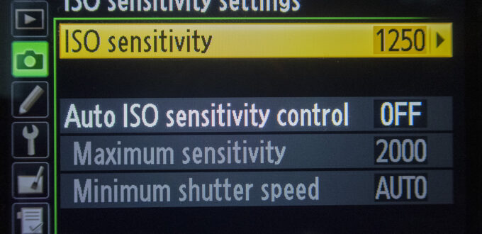
ISO settings within the menu of a DSLR (Nikon D610)
What does ISO mean?
Okay, so what exactly is ISO? ISO is the acronym for the International Organisation for Standardisation (ISO was decided on as the initials would be different depending on the language used). The ISO still exists (with its own website) it sets standards for everything from aircraft components to surgical instruments to building construction. But that doesn’t really tell us anything about what it is, or does, in relation to cameras. The name dates back to film cameras, and was originally called ASA, an acronym for American Standards Association, if the film was from the USA (e.g. Kodak film) or DIN, the Deutsches Institut fur Normung, if the film was from Germany (e.g. Agfa film). These were simply national standards associations that standardised a great many things, from computer programming languages to thread sizes on machine bolts. DIN and ASA film speed standards became shortened to DIN and ASA on the labels on camera film. There was also a Soviet standards system known as GOST (Gosudarstvennyy Standart) which was also used for film in Soviet and some asian countries. When these standards were amalgamated into the ISO system so the film speed standards were changed to ISO. For example ASA 100, and DIN 21, became ISO 100/21; ASA 200 and DIN 24 became ISO 200/24 (often the logarithmic DIN part was omitted e.g. the 21 or 24 in these examples). Similarly GOST 90 became ISO 100, GOST 180 became ISO 200. So that explains where the name came from, but not what ISO actually is.
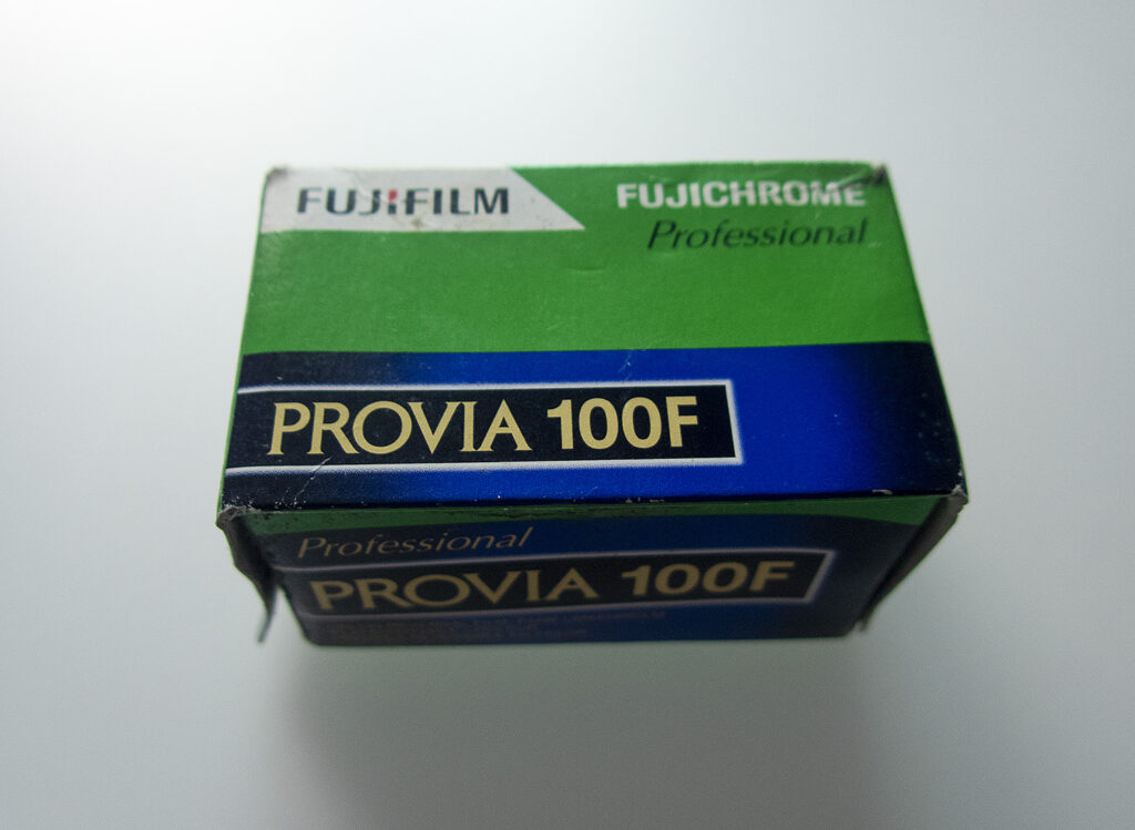
Fuji Provia 100 Film box. The 100 indicates this is 100 ISO film
ISO speed in Film
As explained above, the term ISO (or ISO speed) originated in camera film, so lets start there. Unlike shutter speed and aperture size, ISO works rather differently in film and in digital photography. Those of you old enough to have used film cameras may remember we used to talk about ‘fast film’ and ‘slow film’. This referred to how much light was required to correctly expose the film. Fast film required relatively little light (and so could be exposed at faster shutter speeds, all other things being equal) while slow film required more light.
Fuji Provia ISO 100/21. The 100 indicates the arithmetic scale (same as ASA) the 21 indicates the logarithmic scale (the same as the older DIN system)
Film has light-reactive silver halide grains embedded in one or more layers of gelatin. Fast film has larger grains, slow film has smaller. As photons of light hit each grain it changes state, producing what is known as a latent image, across the film frame. But, and this is the crucial part, it takes roughly the same number of photons to change the state on a larger grain as it does on a smaller one. As the larger grains present more surface area, and there are fewer of them packed across the film frame, so fewer photons of light need to hit the exposed frame of larger grained film than fine grained film to produce the same exposure level. The downside of this was that fast film produced a ‘grainy’ look in the final image. This could look pretty cool in black and white photographs, not so much in colour (at least that’s my personal opinion). Now the thing about ISO in the days of film, it was fixed – more or less. By that I mean you bought a roll of film of a set ISO value, determined by the average size of the silver halide grains embedded in the film. So that could be Kodak 64, or maybe Fiju Velvia 100, both slow, fine grained films of set ISO values 64 and 100 respectively. And once loaded into your camera that was it. You set the ISO on the camera (normally a calibrated wheel on the top of the camera body) to the ISO value of the film, and exposed each shot based on that value. Well almost set. You could, if really necessary, ‘push’ the film. That is you could expose the film as if the ISO was one or two stops faster, then adjust the film processing times (extending the times in chemical baths) to account for this. I say ‘if really necessary’ because it did tend to shift the colours and contrast somewhat.
ISO speed in Digital Cameras
Okay, so that’s how ISO works in film cameras, but there is no film in digital cameras, and no silver halide grains, so what happens there? In digital cameras things work rather differently. The amount of light hitting the sensor (as opposed to the film frame) is still governed by by the size of the aperture and the duration the shutter is open (we now also have electronic shutters, but I won’t go there). However, the sensor itself does not become more or less sensitive to light as the ISO changes. Instead the process is one of changing the output voltage or charge on amplifier circuits, rather like changing the volume on an audio amplifier.
Although ISO speed changes are achieved in fundamentally different ways in film cameras and digital cameras the effect on exposure is almost the same. For example, changing the ISO from 100 to 200 changes the exposure, for the same amount of light reaching the film or sensor, by the same amount in either system. So changing from 100 to 200, or 200 to 400, changes the exposure by one full stop (i.e. the equivalent of doubling of the amount of light hitting the sensor or film). There is of course one crucial difference. As explained earlier, in film the ISO is set, it is a physical feature of the composition of the film. You want to change the ISO you need to load new film, which of course means using all the film currently in the camera first. But with digital cameras the ISO can be varied simply by pressing a button or turning a dial.
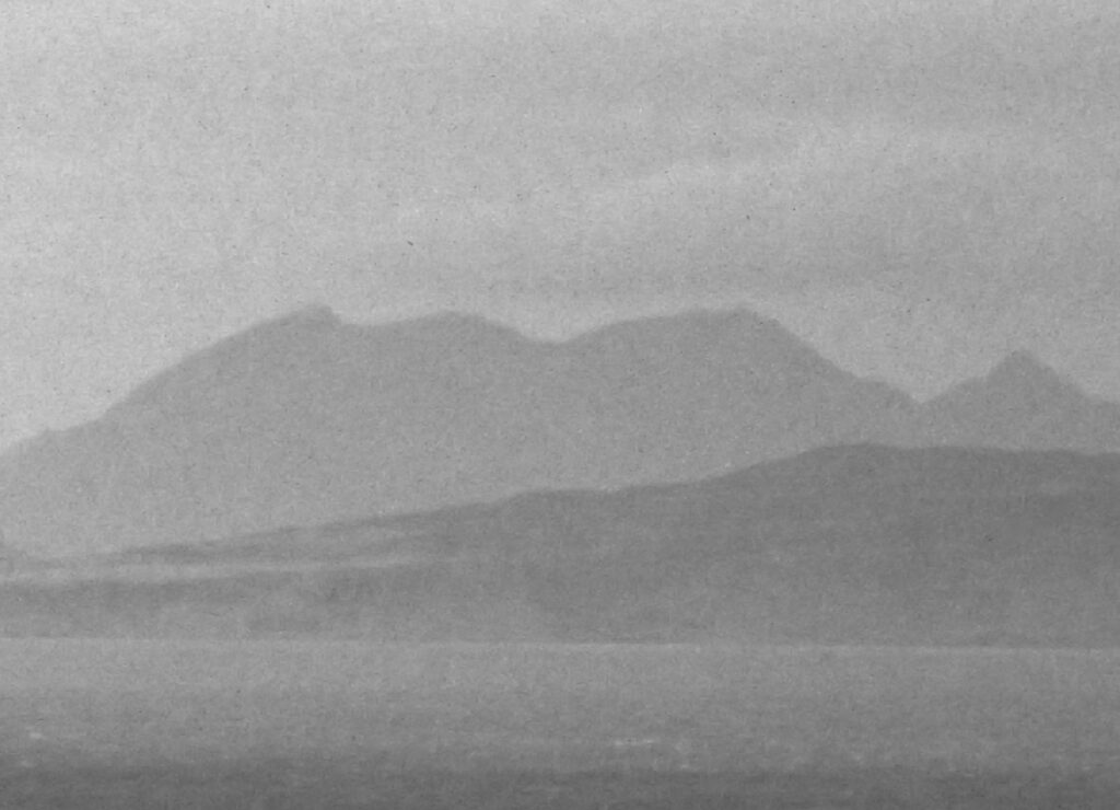
Even though this was slow film (Fuji ISO 100) grain can still be seen in the detail of this older film image I took several decades ago of the Small Isles from the Ardnamurchan peninsula, Scottish Highlands.
High ISO. Image grain and image noise
There is another difference also nowadays. With film, slow, fine detailed, ISO is between 50 and about 200. Fast, grainy ISO is between 800 and 3200, 3200 being pretty specialist film. In the early days of widely available digital cameras (early 2000s) ISO 800 was considered pretty fast for digital cameras also. With the Nikon D200, for example (introduced in 2005) the ISO could be ramped up all the way to 1600. But it came at a price. Where analogue film produced grainy images from high ISO film, digital cameras produced ‘noisy’ images at high ISOs. What exactly are ‘noisy’ images? Noise in images is similar to the distortion in an audio system when the amplifier is turned up too high. How this amplification is achieved in in digital cameras depends on the type of sensor used (CCD or CMOS) and on the manufacturer and model.
Noise in a modern digital image. This is a crop of an image blown up to 200%. The image was taken at ISO 4000 to illustrate noise.
But fundamentally the light hitting the sensor is converted in to a voltage or charge. This voltage or charge is then amplified. At this stage it is still analogue, so any unwanted artifacts present are also amplified. This can manifest itself as random flecks of colour or brightness in the final image. For this reason the rule used to be to take a photograph at the lowest practical ISO in order to have as little noise as possible in the final image. However, the processing of images within digital cameras has advanced so much in recent years that (at the time of writing) ISOs of 6400 or even 12800 are now commonly available with only minimal amounts of noise in the final image (the Nikon Z8 has a maximum ISO (in extended range) of 102,400). An advantage of higher, useable ISO settings is that it allows sharp, detailed images of fast moving objects to be taken in low light conditions that would simply not have been possible only a few years ago. In point of fact, I would argue that improvements in high ISO image quality have been the more meaningful developments in digital cameras over that past 15 years. I still own a very old DSLR from around 2006 (a Nikon D200 as it happens). It is an excellent camera that still serves my purposes perfectly well – most of the time. The one area it falls down on is in low light conditions where I need to use high ISO.
Fine Art Landscape and Wildlife Prints
If you enjoyed this story why not check out my other blogs. I write about travel, the environment, marine biology, diving and wildlife. You may also want to check out my photographic prints. These can be viewed on my main site www.colinmunrophotography.com and include landscapes from around the World, people of the World, marine life and other wildlife. The prints are only available through my website, each one individually processed and made to order. This includes fine art giclee prints, limited edition prints and canvas wraps. I use only the best, carefully selected print houses employing the finest papers and printing processes to ensure image fidelity and longevity.
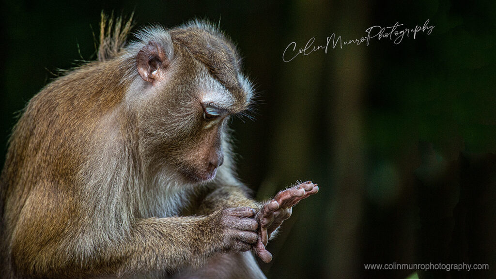
A northern pig-tailed macaque thoughtfully inspects the back of its hand while grooming its fur.
Caught in shafts of light on the edge of the forest, a pig-tailed macaque is wholly absorbed as it inspects the fur on the back of its hand. The behaviour and pose are strikingly human, and reminded me of how much we have in common with our primate cousins.
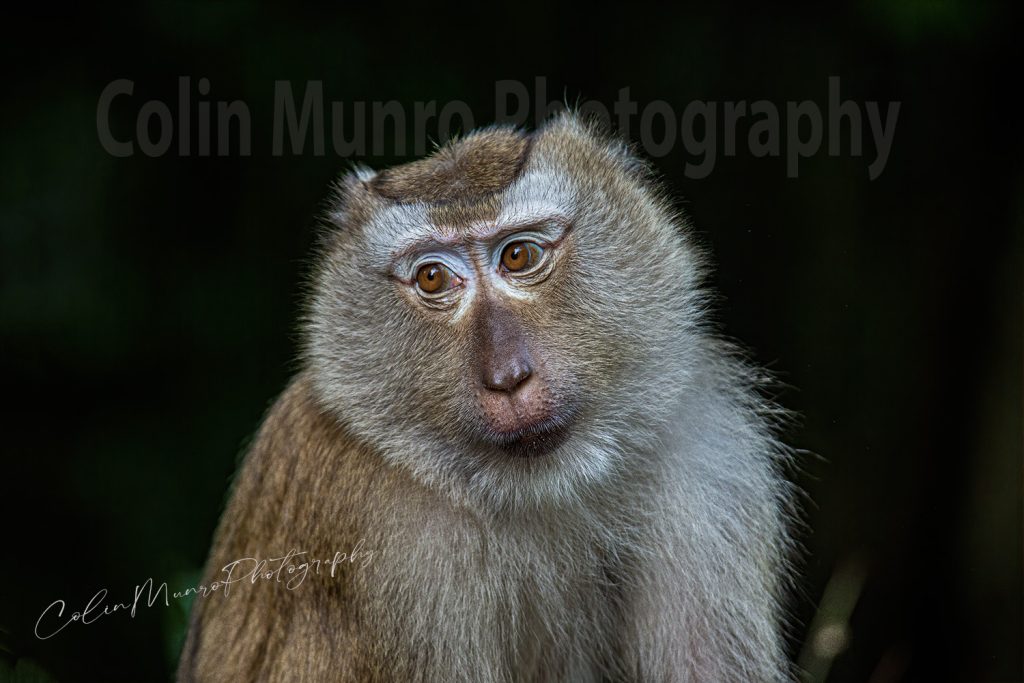
This is an adult male northern pig-tailed macaque. Until quite recently pig-tailed macaques were considered one species, Macaca nemestrina, with the northern pig-tailed classed as a sub-species. However studies conducted in the early 2000s (e.g. Gippoliti, 2001) looking more closely at anatomical and behavioural differences, determined that the differences were so significant that they should be considered two distinct species. The southern pig-tailed macaque retained the original scientific name (M. nemestrina) while the northern pig-tailed macaque (previously the sub-species M. nemestrina leonina) was elevated to full species level and given the new scientific name Macaca leonina. However this change remained scientifically controversial until quite recently, and only in the past few years has it become fully accepted. The most recent (at time of writing) research on speciation of pig-tailed macaques in South East Asia, using analysis of differences in mitochondrial DNA proteins to determine molecular clock timelines, suggests that northern pig-tailed macaques separated from their southern brethren around 1.7 million years ago, and from the Siberut macaque of Western Indonesia only just over one million years ago (Abdul-Latiff and Md-Zain, 2021). Both northern and southern pig-tailed macaques occur in Thailand, with the boundary between ranges of the two species believed to lie in the Krabi region of Southern Thailand. I photographed this guy on the island of Phuket, which is very close to this boundary. The lighter colour fur, white flashes above the eyes and a thin red line running from the corner of the eye towards the ear, mark him out as distinctly a northern pig-tailed.
A northern pig-tailed macaque, Macaca leonina, caught in shafts of sunlight
Pig-tailed macaques are denizens of lowland and hill rainforest through much of South-East Asia. However in many locations their natural habitat is disappearing rapidly as rainforest are cleared to make way for palm oil and rubber plantations, rice paddy fields and urban development. Because of this northern pig-tailed macaques are classed as a vulnerable species by the IUCN. They are primarily fruit eating, but will also take leaves, birds eggs, insects and caterpillars, and are not averse to raiding palm oil and fruit tree plantations. Along with their relatives the crab-eating macaques (Macaca fascicularis) pig-tailed macaques have learned to live alongside humans. In Phuket the inhabit the forests and mangroves (in the case of crab-eating macaques) fringing towns and villages, especially along the eastern shores, and will often congregate in tourist areas drawn to handouts of bananas. The habituation to humans brings numerous problems. The monkeys develop a taste for the easy pickings of tourist handouts and the risks of infection and injury due to bites or scratches from fearless monkeys is significant. But for me it is the similarities between us that are the most fascinating; the strong social bonding, the way a youngster will play with a leaf or a discarded plastic drink bottle just like a small child, or the way an adult will stare at the back of his hand as if in deep introspection, and for all we know maybe he is.
References
Gippoliti S. 2001. on the taxonomy of Macaca nemestrina leonina Blyth, 1863 (Primates: Cercopithecidae). Hystrix It J Mamm 12:51–54. doi:10.4404/hystrix-12.1-4171.
Muhammad Abu Bakar Abdul-Latiff, Badrul Munir Md-Zain. 2021. Taxonomy, Evolutionary and Dispersal Events of Pig-Tailed Macaque, Macaca nemestrina (Linnaeus, 1766) in Southeast Asia with Description of a New Subspecies, Macaca nemestrina perakensis in Malaysia. Zool Stud. 2021; 60: e50. Published online 2021 Oct 8. doi: 10.6620/ZS.2021.60-50PMCID: PMC8685347
About these images
I took these shots late afternoon, on the edge of some forest on the eastern side of Phuket Island, Southern Thailand. The macaque had just climbed down from a tree and was perfectly lit by the low-angled sun, while the forest behind was in deep shade. The images were taken with a Nikon full-frame DSLR; the full size image is around 80 megapixels. These images of pig-tailed macaques are available as Fine Art Prints to purchase on my main website.
Fine Art Landscape and Wildlife Prints
If you enjoyed this story why not check out my other blogs. I write about travel, the environment, marine biology, diving and wildlife. You may also want to check out my photographic prints. These can be viewed on my main site colinmunrophotography.com and include landscapes from around the World, people of the World, marine life and other wildlife. The prints are only available through my website, each one individually processed and made to order. This includes fine art paper prints, acrylic prints and and ready-to-hang canvas prints. I use only the best, carefully selected print houses employing the finest papers and printing processes to ensure image fidelity and longevity.


